

Understanding Low-Inclination Remote Sensing Satellites
The world of space technology is constantly advancing, with new satellites being launched to serve a growing range of purposes. Among these, remote sensing satellites play a critical role in observing and gathering data about Earth’s surface from space. While many satellites orbit the Earth in polar or near-polar paths, a developing area of interest is the deployment of satellites in low-inclination orbits. These orbits offer unique advantages for specific applications, particularly in regions closer to the equator. Understanding the structure and function of these low-inclination remote sensing satellites is key to appreciating their growing importance in fields like environmental monitoring, disaster management, and resource exploration.
What is a Low-Inclination Orbit?
To grasp the significance of low-inclination remote sensing satellites, it’s essential to understand what an orbit is and what “inclination” means in this context. A satellite orbits the Earth following a path determined by its velocity and the Earth’s gravitational pull. The Earth rotates on its axis, and the plane of this rotation is called the equatorial plane.
Inclination refers to the angle between a satellite’s orbital plane and the Earth’s equatorial plane. An orbit with an inclination of 0 degrees would lie directly above the equator. An orbit with an inclination of 90 degrees would pass over both the North and South Poles, essentially a polar orbit. Low-inclination orbits are those with an inclination angle significantly less than 90 degrees, typically ranging from near 0 degrees up to around 30 degrees.
Satellites in low-inclination orbits spend most of their time over the tropical and subtropical regions of the Earth. This is in contrast to polar-orbiting satellites, which pass over or near the poles and thus cover the entire globe over time, including the polar regions. The specific altitude of the orbit also matters; low Earth orbit (LEO) generally refers to altitudes between 160 and 2,000 kilometers above Earth’s surface. The Xiguang-4 01 satellite, for example, was placed in a 541 km-altitude low Earth orbit, which is well within the LEO range and can be considered for low-inclination applications.
The Advantages of Low-Inclination Remote Sensing
The unique path of satellites in low-inclination orbits provides several distinct advantages for remote sensing applications. These benefits are particularly relevant for understanding and managing regions that are often underserved by traditional polar-orbiting satellites.
Focused Regional Coverage
One of the primary advantages is the ability to provide focused, high-frequency coverage of specific regions, especially those near the equator. Unlike polar orbits that sweep across the entire globe, low-inclination orbits concentrate their observations over tropical and subtropical zones. This is invaluable for countries and regions located within these latitudes, allowing for more detailed and frequent data collection. For instance, the Xiguang-4 01 satellite is designed to provide commercial remote sensing services for areas like the Guangdong-Hong Kong-Macao Greater Bay Area and low-latitude regions along the Maritime Silk Road. This targeted approach ensures that data is collected where it is most needed for local applications.
Enhanced Temporal Resolution
For certain applications, the ability to observe a specific area multiple times a day or week is crucial. While polar-orbiting satellites might pass over a given spot only once or twice a day, a constellation of satellites in carefully managed low-inclination orbits can significantly increase the temporal resolution. This means that changes occurring over short periods, such as weather patterns, agricultural growth, or the progression of a natural disaster, can be monitored more closely. This enhanced temporal resolution is vital for timely decision-making in dynamic environments.
Access to Equatorial Data
Many of the Earth’s most biodiverse ecosystems, significant agricultural zones, and densely populated areas are located in tropical and subtropical regions. These areas also experience unique weather phenomena, such as monsoons and typhoons, and are often vulnerable to natural disasters. Low-inclination orbits are ideally suited to gather detailed data on these critical regions, providing insights that might be less frequent or detailed from other orbital paths. This focused data collection supports better understanding and management of these vital parts of the planet.
Potential for Specialized Constellations
The development of constellations, or networks of multiple satellites working together, in low-inclination orbits opens up new possibilities. A constellation like the Wuyang Constellation, described as the world’s first low-inclination remote sensing constellation, aims to provide comprehensive services by having several satellites operating in concert. This allows for greater redundancy, improved data acquisition capabilities, and the potential to cover larger areas with higher frequency than a single satellite could manage. Such constellations can be tailored to specific service needs, offering a more robust and responsive remote sensing solution.
Applications of Low-Inclination Remote Sensing Satellites
The data gathered by low-inclination remote sensing satellites has a wide array of practical applications, impacting various sectors and contributing to global understanding and management of Earth’s resources and challenges.
Natural Resource Monitoring
Accurate monitoring of natural resources is essential for sustainable development and economic planning. Satellites in low-inclination orbits can provide detailed imagery for tracking changes in forests, water bodies, and land use patterns in tropical and subtropical regions. This data helps in managing deforestation, monitoring water availability, and assessing the health of ecosystems. For example, agricultural production in these regions can be monitored to assess crop health, predict yields, and identify areas in need of intervention.
Agricultural Production
The agricultural sector heavily relies on timely and accurate environmental data. Low-inclination satellites can monitor crop growth stages, soil moisture levels, and the impact of weather events on farmlands. This information is crucial for farmers, agricultural businesses, and governments to optimize planting and harvesting schedules, manage irrigation, and respond to potential crop failures. The ability to observe agricultural areas frequently allows for early detection of pests or diseases, enabling proactive measures to be taken.
Marine Observation
Coastal areas and oceans in tropical and subtropical zones are vital for fisheries, shipping, and climate regulation. Remote sensing satellites can monitor sea surface temperature, ocean currents, marine pollution, and the health of coral reefs. This data is essential for managing fisheries sustainably, tracking the movement of marine life, predicting weather patterns affecting maritime activities, and understanding the impact of climate change on marine ecosystems. The frequent revisits offered by low-inclination orbits are particularly useful for tracking dynamic oceanographic phenomena.
Ecological Protection and Climate Change Monitoring
Tropical regions are home to a significant portion of the Earth’s biodiversity and play a crucial role in global climate regulation. Low-inclination satellites can monitor deforestation, land degradation, and changes in vegetation cover, which are critical indicators of ecological health. They can also track the effects of climate change, such as changes in rainfall patterns, the expansion of deserts, and the health of sensitive ecosystems like rainforests and mangroves. This data supports conservation efforts and informs climate policy.
Disaster Management and Emergency Response
Natural disasters, such as floods, typhoons, and droughts, frequently impact low-latitude regions. Remote sensing satellites can provide rapid and accurate information before, during, and after such events. Pre-disaster, they can help in mapping vulnerable areas and planning evacuation routes. During a disaster, they can assess the extent of damage, identify affected populations, and guide rescue efforts. Post-disaster, they can monitor recovery processes and aid in rebuilding efforts. The ability of low-inclination satellites to provide frequent updates is particularly valuable in the fast-changing scenarios of disaster response.
Urban Governance and Development
As urban populations grow, especially in tropical and subtropical regions, effective urban planning and management become increasingly important. Remote sensing data can help monitor urban sprawl, assess infrastructure development, manage traffic flow, and monitor environmental quality within cities. This information supports city planners and local governments in making informed decisions about land use, transportation, and public services, contributing to more sustainable and livable urban environments.
Technological Advancements in Low-Inclination Satellite Systems
The successful deployment and operation of low-inclination remote sensing satellites rely on significant technological advancements in several key areas. These innovations ensure that the satellites are capable, reliable, and cost-effective.
Launch Vehicle Capabilities
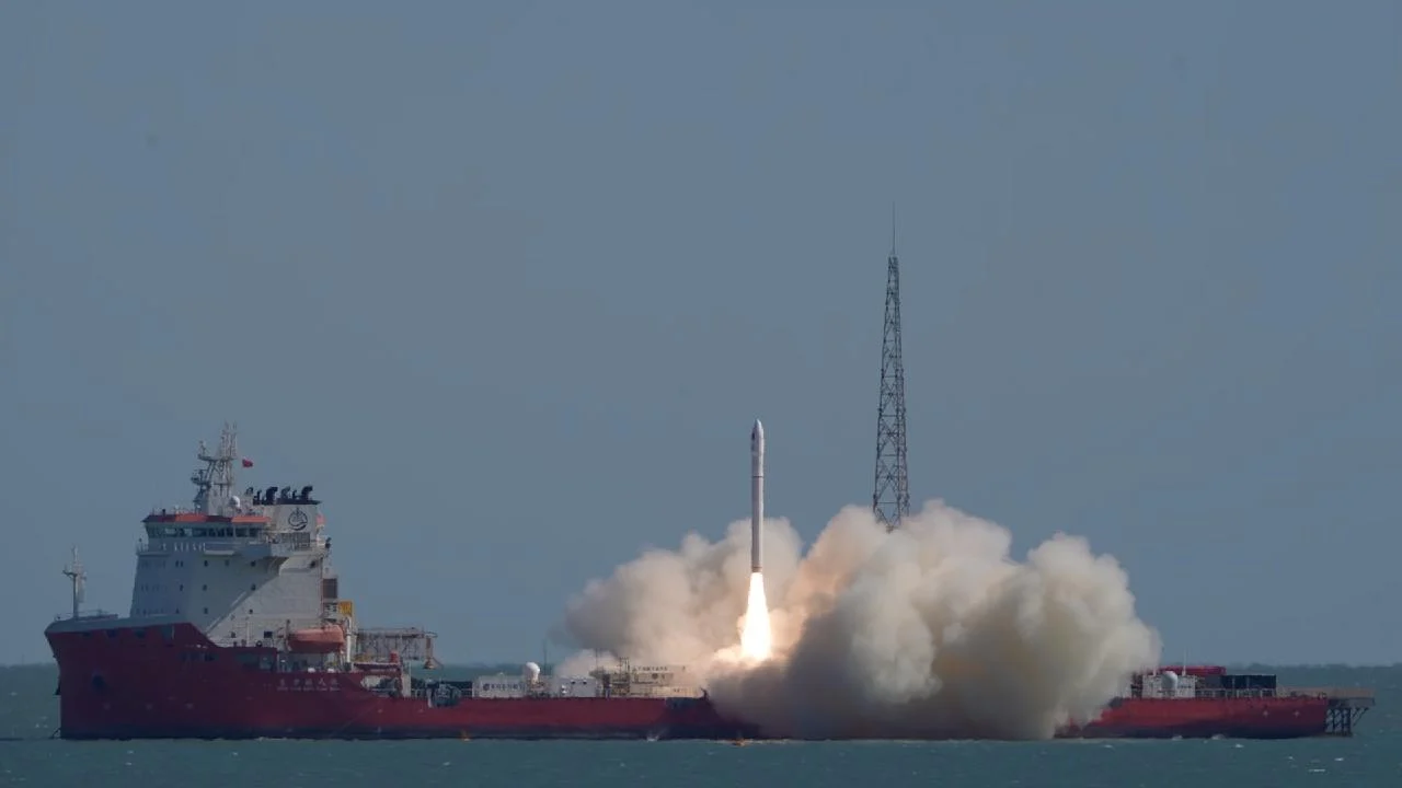
The ability to place satellites into specific orbits depends heavily on the capabilities of launch vehicles. Companies like Galactic Energy are developing advanced rockets, such as the CERES-1 rocket model, which can launch satellites from both land and sea platforms. The CERES-1S, a variant of this model, has demonstrated a consistent launch success rate, including sea launch missions. This flexibility in launch capability is important for deploying satellites into precise low-inclination orbits and for responding quickly to the need for new or replacement satellites. Sea launches, in particular, can offer advantages in terms of launch trajectory flexibility and safety.
Satellite Design and Payload
The satellites themselves are designed with specific payloads to capture the required data. For remote sensing, this often includes high-resolution cameras, multispectral sensors, and radar systems. The Xiguang-4 01 satellite, for example, is designed to provide commercial remote sensing services, implying it carries advanced imaging technology. Miniaturization of components and improvements in sensor technology allow for more powerful instruments to be fitted into smaller, more cost-effective satellites, which is crucial for building constellations.
Constellation Management and Data Processing
Operating a constellation of satellites in low-inclination orbits requires sophisticated systems for managing their positions, ensuring they do not collide, and coordinating their data collection. Advanced software and ground control systems are needed to maintain optimal orbital configurations and task satellites efficiently. Furthermore, the vast amounts of data generated by these satellites need to be processed, analyzed, and distributed quickly. This involves developing efficient data pipelines, utilizing artificial intelligence and machine learning for image analysis, and creating platforms for users to access and interpret the data.
Commercialization and Service Provision
The trend towards commercializing space activities means that more private companies are involved in developing and operating remote sensing satellites. This competition drives innovation and can lead to more affordable and accessible data. The focus on providing “commercial remote sensing services,” as mentioned for the Xiguang-4 01, indicates a shift towards offering tailored solutions to specific industries and governments, rather than just raw data. This commercial approach can accelerate the adoption of satellite technology for practical applications.
Challenges and Future Outlook
Despite the significant advantages and ongoing advancements, the deployment and utilization of low-inclination remote sensing satellites also face challenges.
Orbital Congestion and Space Debris
As more satellites are launched into LEO, concerns about orbital congestion and space debris are growing. Low-inclination orbits, like all LEO paths, are becoming increasingly crowded. Managing this congestion and mitigating the risk of collisions is crucial for the long-term sustainability of space activities. International cooperation and stricter regulations on satellite deployment and deorbiting are necessary to address this challenge.
Data Interoperability and Standardization
With various countries and companies launching their own remote sensing satellites, ensuring data interoperability and standardization can be a challenge. Different sensors and data formats can make it difficult to combine data from multiple sources for comprehensive analysis. Efforts towards developing common standards and protocols for data acquisition, processing, and sharing are important for maximizing the utility of global remote sensing capabilities.
Cost and Accessibility
While commercialization aims to reduce costs, the initial investment in developing, launching, and operating satellite systems remains substantial. Ensuring that the benefits of low-inclination remote sensing are accessible to all nations, particularly developing countries in tropical regions, requires innovative funding models and capacity-building initiatives.
Future Trends
The future of low-inclination remote sensing satellites looks promising. We can expect to see:
- More sophisticated constellations: Larger and more capable constellations designed for specific applications, offering higher resolution and more frequent revisits.
- Integration with other technologies: Combining satellite data with ground-based sensors, drones, and AI for more comprehensive environmental monitoring and analysis.
- New sensor technologies: Development of advanced sensors capable of detecting a wider range of atmospheric and terrestrial phenomena.
- Increased focus on climate and environmental applications: As the impacts of climate change become more pronounced, low-inclination satellites will play an even more critical role in monitoring and understanding these changes, especially in vulnerable equatorial regions.
The launch of satellites like Xiguang-4 01 marks a significant step in expanding our ability to observe and understand Earth, particularly the vital regions near the equator. As technology continues to evolve, these specialized orbital systems will undoubtedly become even more indispensable tools for addressing global challenges and fostering sustainable development.
Conclusion
Low-inclination remote sensing satellites represent a specialized yet increasingly important segment of Earth observation technology. By focusing their orbits on tropical and subtropical regions, they offer unique advantages in terms of focused coverage and temporal resolution. These capabilities are vital for a wide range of applications, from monitoring natural resources and agricultural production to supporting disaster response and urban governance in the world’s equatorial belt. While challenges related to orbital congestion and data accessibility exist, ongoing technological advancements and the growing commercial interest in space suggest a bright future for these systems. As we continue to face complex global issues, the detailed insights provided by low-inclination remote sensing satellites will be indispensable for informed decision-making and sustainable planetary management.



Conversation
0 Comments