

The Role of Technology in Disaster Response and Recovery
When disaster strikes, the immediate aftermath is a race against time. Every second counts in saving lives, assessing damage, and beginning the long road to recovery. In this critical period, technology has emerged as an indispensable tool, transforming how we respond to and manage catastrophic events. From the initial moments of an earthquake to the sustained efforts of rebuilding, advanced technological solutions are providing unprecedented capabilities for communication, assessment, and aid delivery. This analysis explores the multifaceted role of technology in disaster response and recovery, highlighting its impact on efficiency, effectiveness, and the overall well-being of affected communities.
The integration of technology into disaster management is not a new concept, but its sophistication and accessibility have grown exponentially. Satellites, drones, advanced communication networks, and data analytics are now standard components of modern disaster response strategies. These tools offer real-time information, enable rapid deployment of resources, and facilitate coordination among various agencies and organizations. The ability to quickly understand the scope of a disaster, identify areas of greatest need, and deliver targeted assistance can significantly reduce loss of life and minimize long-term damage.
Satellite Technology: Eyes in the Sky
Satellite technology plays a pivotal role in disaster management, offering a bird’s-eye view of affected areas that is often inaccessible by ground. These orbiting platforms provide crucial data for early warning systems, damage assessment, and ongoing monitoring. Their ability to cover vast geographical regions, regardless of terrain or infrastructure damage, makes them invaluable assets in the face of natural calamities.
Real-Time Imaging and Monitoring
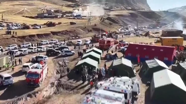
Following a disaster, satellites can quickly capture high-resolution images of the affected zone. This imagery is essential for understanding the extent of damage to buildings, infrastructure, and natural landscapes. For instance, after a major earthquake, satellite images can reveal collapsed structures, flooded areas, and damaged roads, helping emergency responders prioritize their efforts. The China Aerospace Science and Technology Corporation (CASC) frequently deploys satellite resources for emergency communications and imaging in disaster-stricken regions, as seen in their response to a magnitude-7.0 earthquake in China’s Xizang Autonomous Region. This rapid imaging allows for swift damage assessment and helps in planning rescue operations.
Communication and Connectivity
In areas where traditional communication networks are destroyed or overloaded, satellites provide a vital lifeline. Satellite-based internet services can be quickly established, enabling emergency personnel to communicate with each other and with command centers. This ensures that rescue teams have access to critical information and can coordinate their actions effectively. CASC has been instrumental in opening high-throughput satellite internet lines for emergency management ministries and telecommunication operators, ensuring that essential communication channels remain open even when ground infrastructure fails. This capability is particularly important in remote or hard-to-reach disaster zones.
Navigation and Mapping
Satellite technology also underpins global positioning systems (GPS) and other navigation tools. These systems are critical for guiding rescue teams to specific locations, mapping out safe routes, and tracking the movement of personnel and resources. In complex disaster environments, accurate navigation can mean the difference between reaching a trapped survivor or getting lost. Furthermore, satellite data can be used to create detailed maps of the disaster area, highlighting critical features like damaged bridges, accessible roads, and potential hazards.
Drones: Versatile Tools for On-the-Ground Assessment
Drones, also known as unmanned aerial vehicles (UAVs), have become increasingly important in disaster response due to their agility, cost-effectiveness, and ability to operate in hazardous conditions. They can provide close-up views of damage, deliver essential supplies, and assist in search and rescue operations.
Damage Assessment and Reconnaissance
Drones equipped with cameras and sensors can fly over disaster sites at low altitudes, capturing detailed visual information. This allows for a more granular assessment of damage than satellite imagery alone. For example, a drone can inspect the structural integrity of a damaged building, identify gas leaks, or locate individuals trapped in rubble. The Aviation Industry Corporation of China (AVIC) has utilized Wing Loong drones for damage observation and communication support in earthquake zones, demonstrating their effectiveness in real-time reconnaissance. The People’s Liberation Army Air Force has also employed drones for similar surveying missions.
Search and Rescue Operations
Drones can be equipped with thermal imaging cameras to detect heat signatures of survivors, even in low visibility conditions or at night. They can also carry loudspeakers to communicate with trapped individuals or drop small, essential supplies like medicine or communication devices. Their ability to navigate confined spaces and reach areas inaccessible to human rescuers makes them invaluable in search and rescue efforts.
Delivery of Urgent Supplies
In situations where roads are impassable, drones can be used to deliver small, critical items such as medical supplies, food, or water to isolated communities or individuals. This capability can be life-saving in the immediate hours and days following a disaster, bridging the gap until larger-scale aid can be delivered.
Mapping and Surveying
Beyond immediate response, drones can be used for detailed mapping and surveying of disaster-affected areas. This data is crucial for planning reconstruction efforts, monitoring environmental changes, and assessing the long-term impact of the disaster. They can create 3D models of damaged areas, providing valuable information for engineers and urban planners.
Advanced Communication Systems: Keeping Lines Open
Effective communication is the backbone of any successful disaster response. When traditional infrastructure fails, advanced communication systems become critical for coordinating efforts, disseminating information, and ensuring the safety of both responders and the public.
Mobile Communication Networks
While often vulnerable to damage, efforts are made to rapidly restore or supplement mobile communication networks in disaster zones. This includes deploying mobile base stations, often mounted on trucks or trailers, to provide temporary cellular service. These systems allow affected individuals to contact loved ones and emergency services, and enable responders to maintain contact with their teams.
Satellite Phones and Terminals
Satellite phones offer a reliable alternative when terrestrial networks are down. They can be used by emergency personnel to communicate from virtually anywhere in the world. Additionally, satellite terminals can provide internet connectivity for data transfer, video conferencing, and access to critical information systems. The rapid deployment of satellite internet lines by organizations like CASC highlights their importance in ensuring connectivity during emergencies.
Emergency Communication Platforms
Specialized communication platforms are designed for disaster scenarios. These can include secure radio systems, mesh networks that create ad-hoc communication systems, and digital platforms that allow for the sharing of real-time information, incident reports, and resource requests among different agencies. These platforms often integrate with other technologies, such as GPS tracking and mapping software, to provide a comprehensive operational picture.
Data Analytics and Artificial Intelligence: Informing Decisions
The sheer volume of data generated during a disaster can be overwhelming. Data analytics and artificial intelligence (AI) are increasingly being used to process this information, identify patterns, and provide actionable insights to decision-makers.
Predictive Modeling and Early Warning
AI algorithms can analyze historical data, weather patterns, and seismic activity to predict the likelihood and potential impact of disasters. This allows for the development of more effective early warning systems, giving communities more time to prepare and evacuate. By identifying potential risks, authorities can pre-position resources and develop targeted response plans.
Damage Assessment and Resource Allocation
AI can analyze satellite imagery, drone footage, and social media data to automatically identify damaged areas and estimate the severity of destruction. This speeds up the damage assessment process significantly, allowing for more efficient allocation of resources. AI can also help optimize the distribution of aid by identifying areas with the greatest need and the most accessible routes for delivery.
Situational Awareness and Coordination
Data analytics platforms can integrate information from various sources, including sensor networks, communication logs, and field reports, to create a comprehensive real-time picture of the disaster situation. This enhanced situational awareness allows incident commanders to make better-informed decisions, coordinate the actions of different response teams, and adapt their strategies as the situation evolves.
Identifying Vulnerable Populations
AI can analyze demographic data and social media sentiment to identify vulnerable populations who may require special assistance, such as the elderly, disabled, or those living in isolated areas. This helps ensure that aid is distributed equitably and that no one is left behind.
Geographic Information Systems (GIS): Mapping the Response
Geographic Information Systems (GIS) are powerful tools for managing and analyzing spatial data. In disaster management, GIS enables the creation of detailed maps that support planning, response, and recovery efforts.
Disaster Mapping and Visualization
GIS software allows for the creation of dynamic maps that display critical information such as the extent of the disaster zone, locations of damaged infrastructure, evacuation routes, and the distribution of relief resources. These maps provide a clear visual representation of the situation, aiding in decision-making and communication among response teams.
Resource Management and Logistics
GIS can be used to track the location and status of emergency response assets, such as vehicles, personnel, and supplies. This helps in optimizing resource allocation, ensuring that resources are deployed where they are needed most, and managing logistics for efficient delivery of aid.
Damage Assessment and Analysis
By overlaying pre- and post-disaster imagery and data, GIS can quantify the extent of damage and identify areas that require immediate attention. This analysis is crucial for prioritizing repair and reconstruction efforts and for assessing the economic and social impact of the disaster.
Evacuation Planning and Management
GIS plays a key role in planning and executing evacuation procedures. It can identify safe evacuation routes, determine the capacity of shelters, and monitor the movement of people during an evacuation, helping to ensure the safety and efficiency of the process.
Social Media and Crowdsourcing: Real-Time Information and Community Engagement
In the age of smartphones, social media platforms have become a significant source of real-time information during disasters. While often requiring careful verification, crowdsourced data can provide valuable insights into the ground situation.
Real-Time Information Gathering
During a disaster, individuals often turn to social media to share updates, photos, and videos of the situation in their vicinity. This crowdsourced information can alert authorities to developing issues, identify areas of need, and provide early indications of damage. Platforms like Twitter and Facebook can become de facto real-time news feeds for disaster-affected areas.
Situational Awareness and Verification
While social media can be a valuable source of information, it also presents challenges related to misinformation and verification. Response agencies often employ teams to monitor social media, filter relevant information, and verify its accuracy using other data sources, such as satellite imagery or reports from on-the-ground personnel.
Community Support and Information Dissemination
Social media can also be used to disseminate official information, safety instructions, and updates on relief efforts to the affected population. It serves as a platform for community members to connect with each other, offer support, and share information about missing persons or available resources.
Crowdsourced Damage Reporting
Dedicated platforms and apps allow citizens to report damage, request assistance, or offer help. This crowdsourced data can supplement official damage assessments and help responders identify needs more quickly.
Challenges and Future Directions
Despite the significant advancements in technology for disaster response, several challenges remain. These include ensuring equitable access to technology in all affected regions, protecting critical infrastructure from cyber threats, and managing the ethical implications of data collection and usage.
The Digital Divide
Access to technology is not uniform across all communities. Disasters often disproportionately affect marginalized populations who may have limited access to smartphones, internet connectivity, or the digital literacy needed to utilize these tools effectively. Bridging this digital divide is crucial for ensuring that technological advancements benefit everyone.
Cybersecurity and Data Privacy
As disaster response becomes more reliant on digital systems, the risk of cyberattacks increases. Protecting critical communication networks, data repositories, and response platforms from malicious actors is paramount. Furthermore, the collection and use of personal data during disaster response raise important privacy concerns that must be addressed through robust policies and ethical guidelines.
Interoperability and Standardization
Different agencies and organizations often use disparate technological systems that may not be compatible with each other. Ensuring interoperability between these systems is essential for seamless data sharing and coordinated response efforts. Developing common standards for data formats and communication protocols can significantly improve efficiency.
The Role of Emerging Technologies
The future of disaster response will likely involve even more sophisticated technologies. This includes the expanded use of AI for predictive analytics and autonomous response systems, the development of advanced robotics for search and rescue in highly dangerous environments, and the integration of the Internet of Things (IoT) for real-time environmental monitoring.
Conclusion
Technology has fundamentally reshaped the landscape of disaster response and recovery. From the orbital perspective of satellites to the granular detail provided by drones, and from robust communication networks to the analytical power of AI, these tools are empowering us to act faster, more effectively, and with greater precision. While challenges related to access, security, and interoperability persist, the ongoing innovation in technological solutions promises an even more resilient future in the face of adversity. By embracing and strategically deploying these advancements, we can better protect lives, mitigate damage, and accelerate the recovery process for communities impacted by disasters.



Conversation
0 Comments