

Understanding Earthquakes: A Deep Dive into Tectonic Forces and Their Impact
Earthquakes are powerful natural events that remind us of the dynamic forces shaping our planet. While often perceived as a sudden, violent shaking, the underlying causes are complex, involving the slow, constant movement of Earth’s tectonic plates. Understanding these processes is key to comprehending why earthquakes happen, where they are most likely to occur, and how they impact the regions they affect. This article will explore the science behind earthquakes, focusing on the specific geological conditions that lead to seismic activity, particularly in regions like the Xizang Autonomous Region. We will examine the different types of fault movements and how they relate to the broader tectonic picture.
The Earth’s Shifting Plates: A Foundation for Seismic Activity
Our planet’s outer shell, the lithosphere, is not a single, unbroken piece. Instead, it is divided into several large and small tectonic plates that float on the semi-fluid layer beneath them, known as the asthenosphere. These plates are in constant, slow motion, driven by heat from Earth’s interior. This movement is not always smooth; plates can collide, pull apart, or slide past each other. The boundaries between these plates are where most of the Earth’s seismic activity originates.
When these massive plates interact, immense stress builds up along their edges, which are called fault lines. These fault lines are fractures in the Earth’s crust where rocks on either side can move relative to each other. The stress accumulates over time, deforming the rocks. When the stress finally exceeds the strength of the rocks or the friction holding them in place, the rocks break or slip suddenly, releasing stored energy in the form of seismic waves. These waves travel through the Earth and cause the ground to shake, which we experience as an earthquake.
The intensity of an earthquake is measured by its magnitude, which is related to the amount of energy released. The depth of the earthquake also plays a role in how it is felt on the surface. Shallow earthquakes, occurring closer to the surface, tend to cause more intense shaking than deeper ones. The type of fault movement also dictates the nature of the earthquake.
Types of Faults and Their Seismic Signatures
Faults are classified based on the direction of movement of the rocks on either side of the fracture. The three main types of faults are:
-
Normal Faults: These occur when the Earth’s crust is being pulled apart, a process called extension. In a normal fault, the hanging wall (the block of rock above the fault plane) moves down relative to the footwall (the block of rock below the fault plane). This type of fault is common in areas where tectonic plates are diverging, or pulling away from each other. Earthquakes associated with normal faults are typically characterized by a stretching or pulling-apart motion.
-
Reverse Faults (and Thrust Faults): These occur in areas where the Earth’s crust is being compressed. In a reverse fault, the hanging wall moves up relative to the footwall. If the angle of the fault is shallow, it is called a thrust fault. These faults are common at convergent plate boundaries, where plates are colliding. The compressional forces can lead to significant uplift and mountain building, as well as powerful earthquakes.
-
Strike-Slip Faults: These occur when rocks on either side of the fault move horizontally past each other. The movement is predominantly sideways, with little to no vertical displacement. The San Andreas Fault in California is a famous example of a strike-slip fault. Earthquakes on strike-slip faults can be very destructive, as the sudden lateral movement can cause significant ground rupture.
Understanding these fault types is crucial for interpreting the mechanics of specific earthquakes. For instance, a recent magnitude-7.0 earthquake in the Xizang Autonomous Region was identified as an “extensional rupture,” meaning the crust was being stretched apart, not squeezed together. This might seem counterintuitive in a region known for its compressional forces due to the collision of the Indian and Eurasian plates.
The Xizang Earthquake: A Case Study in Tectonic Complexity
The earthquake that struck Baqen County in the Xizang Autonomous Region serves as an excellent example of the complex tectonic forces at play. The China Earthquake Networks Center (CENC) reported that this magnitude-7.0 event was an extensional rupture occurring within the Qiangtang block, near the Baqen-Leiwuqi fault. This finding highlights a key geological concept: even within a generally compressional tectonic setting, localized areas can experience extension.
The collision between the Indian and Eurasian plates has created the vast Tibetan Plateau, characterized by thickened crust and significant uplift. This massive collision generates powerful compressional forces that push the crust from north to south. However, the immense pressure also causes the crust to deform in other ways. The interior of the plateau is subjected to both north-south compression and east-west extension. This dual stress system results in the formation of two sets of faults: those running roughly north-south and those running east-west.
In the case of the Xizang earthquake, the fault involved was oriented in a way that allowed for extensional rupture despite the broader compressional environment. Han Yanyan, a senior engineer at CENC, explained that an extensional rupture means the crust is being stretched horizontally. Under tension and the influence of gravity, the upper block of rock slides down along an existing fault, creating fractures. This is distinct from the compressional forces that typically lead to reverse or thrust faulting.
The Qiangtang block, where the earthquake occurred, has a history of significant seismic activity. Since 1900, it has recorded six earthquakes of magnitude 7.0 or above, with the largest being a magnitude 7.5 event in 1997. The recent earthquake released stored energy within this block, contributing to the region’s seismic history.
Secondary Hazards and Disaster Response
Earthquakes are not just about the initial shaking. They can trigger a cascade of secondary hazards that can be equally, if not more, destructive. In high-altitude regions like Xizang, these secondary hazards can be particularly dangerous.
-
Aftershocks: Following a major earthquake, smaller earthquakes, known as aftershocks, often occur. These can continue for days, weeks, or even months. While typically less powerful than the main shock, aftershocks can cause further damage to already weakened structures, increasing the risk of collapse. In the Xizang event, 23 aftershocks of magnitude 3.0 or above were recorded shortly after the main quake, with the strongest reaching magnitude 4.3. Experts warned that felt tremors could continue in the coming days, emphasizing the need for caution.
-
Landslides and Rockfalls: Earthquakes can destabilize slopes, especially in mountainous terrain. The shaking can loosen rocks and soil, leading to landslides and rockfalls. This is a significant concern in high-altitude areas where steep slopes are common. The Xizang region, with its nearly 4,800-meter elevation, faces this risk, particularly during cold nights when the ground can become more brittle. Geologists were deployed to patrol roads and assess the risk of such events.
-
Structural Collapse: Buildings that are not designed to withstand seismic forces are highly vulnerable. Older structures, or those with visible cracks and damage from the initial quake or aftershocks, pose a serious risk to occupants. Authorities in Xizang warned residents not to return to damaged houses until they were declared safe by inspectors, highlighting the importance of structural integrity assessments in disaster response.
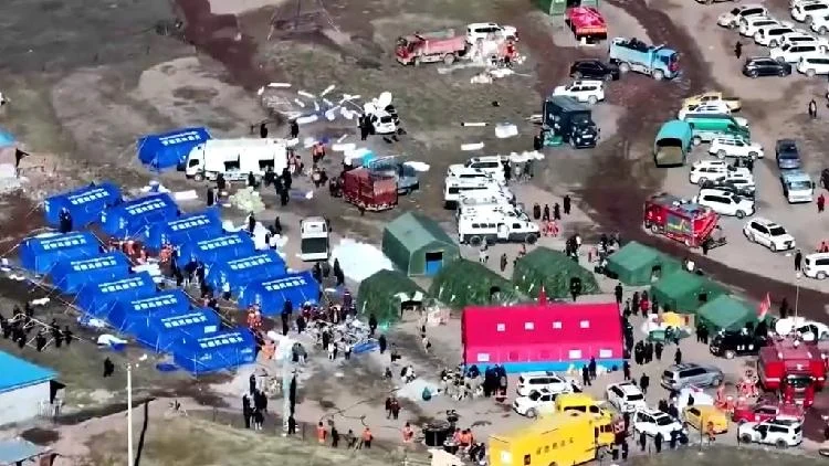
The response to the Xizang earthquake involved a massive mobilization of resources. Over 5,000 rescuers were sent to the disaster zone, demonstrating the scale of the effort required to address the immediate needs of the affected population. Tragically, the earthquake resulted in fatalities and injuries, underscoring the devastating impact of such events.
Plate Tectonics and Global Seismic Patterns
The understanding of plate tectonics revolutionized our view of earthquakes. Before this theory, the causes of earthquakes were largely mysterious, often attributed to supernatural forces or unknown subterranean activities. Plate tectonics provided a scientific framework that explains the global distribution of earthquakes, volcanoes, and mountain ranges.
Most earthquakes occur along the boundaries of tectonic plates, forming distinct seismic zones. The “Ring of Fire,” a horseshoe-shaped zone that encircles the Pacific Ocean, is the most seismically active region on Earth, accounting for about 90% of the world’s earthquakes. This zone is characterized by numerous subduction zones, where one tectonic plate slides beneath another. The friction and stress generated at these boundaries lead to frequent and powerful earthquakes.
Other significant earthquake zones include the Alpide belt, which stretches from the Mediterranean region eastward through Asia, and the Mid-Atlantic Ridge, a divergent plate boundary where new oceanic crust is formed. Even within continental plates, away from the boundaries, earthquakes can occur. These are known as intraplate earthquakes, and they are often less frequent but can be very damaging because the underlying crust is typically older and more rigid, transmitting seismic waves more efficiently.
The study of earthquakes, or seismology, uses seismographs to record ground motion. By analyzing the seismic waves generated by earthquakes, scientists can determine the earthquake’s location, depth, magnitude, and the type of fault movement. This information is vital for understanding Earth’s internal structure and for developing earthquake hazard assessments and early warning systems.
Building Resilience: Mitigation and Preparedness
While earthquakes cannot be prevented, their impact can be significantly reduced through effective mitigation and preparedness strategies. This involves a multi-faceted approach that includes:
-
Seismic Hazard Assessment: Identifying areas prone to earthquakes and understanding the potential intensity and frequency of seismic events is the first step. This involves studying historical earthquake data, geological fault mapping, and analyzing the characteristics of the local ground.
-
Building Codes and Engineering: Implementing and enforcing strict building codes that require structures to be designed and constructed to withstand seismic forces is paramount. This includes using earthquake-resistant materials, designing flexible structures, and reinforcing foundations. Retrofitting older buildings to meet current seismic standards is also crucial.
-
Land-Use Planning: Avoiding construction in areas with high seismic risk, such as directly on active fault lines or in areas prone to liquefaction or landslides, can significantly reduce vulnerability.
-
Public Education and Awareness: Educating the public about earthquake risks, safety measures, and emergency preparedness is essential. This includes teaching people how to secure their homes, what to do during an earthquake (drop, cover, and hold on), and how to prepare an emergency kit.
-
Early Warning Systems: Developing and deploying earthquake early warning systems can provide a few precious seconds to minutes of advance notice before seismic waves arrive. This can allow for automated shutdowns of critical infrastructure, such as gas lines and trains, and give people time to take protective actions.
-
Emergency Response Planning: Having well-rehearsed emergency response plans in place is critical for managing the aftermath of an earthquake. This includes coordinating rescue efforts, providing medical aid, ensuring the distribution of essential supplies, and managing temporary shelter for displaced populations.
The international community also plays a role in disaster response, offering aid and expertise to affected regions. Organizations like the United Nations and various non-governmental agencies often provide assistance in the form of financial aid, supplies, and specialized rescue teams.
The Ongoing Study of Earth’s Dynamics
The study of earthquakes, like the one in Xizang, continues to provide valuable insights into the complex processes that shape our planet. Each seismic event, whether large or small, offers a unique opportunity to refine our understanding of plate tectonics, fault mechanics, and the Earth’s internal structure. The ability to analyze events like the “pull-apart” rupture in a compressional setting demonstrates the ongoing advancements in seismological research and our capacity to interpret these powerful natural phenomena.
As scientists continue to monitor seismic activity and develop more sophisticated modeling techniques, our ability to predict earthquake behavior and mitigate their impact will undoubtedly improve. This ongoing research is not just an academic pursuit; it is a critical effort to protect lives and communities from the ever-present forces of nature. The resilience of human societies in the face of seismic threats depends on a deep understanding of the Earth’s dynamics and a proactive commitment to safety and preparedness.
The application for direct organization’s involvement in disaster relief and preparedness efforts can be found through governmental emergency management agencies and international humanitarian organizations. These bodies often coordinate volunteer efforts and resource allocation during and after seismic events.
Conclusion
Earthquakes are a profound manifestation of Earth’s dynamic nature, driven by the relentless movement of tectonic plates. From the immense compressional forces that build mountain ranges to the localized extensional ruptures that can occur within them, the geological processes are intricate and powerful. Understanding the different types of faults, the stresses they experience, and the secondary hazards they can trigger is fundamental to comprehending seismic events. The recent earthquake in the Xizang Autonomous Region serves as a compelling case study, illustrating how complex tectonic interactions can lead to unexpected seismic behaviors. By continuing to study these phenomena, improving our building practices, and enhancing our preparedness, we can work towards building more resilient communities capable of withstanding the inevitable tremors of our active planet.



Conversation
0 Comments