

Understanding Remote Sensing Satellites and Their Applications
Remote sensing satellites are sophisticated tools that orbit Earth, capturing images and data about our planet’s surface without direct physical contact. These satellites play a critical role in various fields, from environmental monitoring and disaster management to urban planning and agricultural assessment. The ability to gather information from a distance provides a unique perspective, allowing us to understand complex global processes and make informed decisions. This article will explore the fundamental aspects of remote sensing satellites, their technological underpinnings, and the diverse applications that make them indispensable in the modern world.
The Technology Behind Remote Sensing Satellites
At its core, remote sensing involves detecting and measuring electromagnetic radiation reflected or emitted from Earth’s surface. Satellites are equipped with specialized sensors that capture this radiation across different parts of the electromagnetic spectrum, including visible light, infrared, and microwave frequencies. The type of sensor determines the kind of information that can be gathered.
Types of Sensors
Optical Sensors: These sensors work much like the human eye or a digital camera, capturing reflected sunlight. They are effective for distinguishing different types of land cover, such as forests, water bodies, and urban areas, based on their color and texture. However, optical sensors are limited by cloud cover and the availability of sunlight, making them less useful during nighttime or in cloudy regions.
Thermal Infrared Sensors: These sensors detect heat emitted from the Earth’s surface. They are valuable for monitoring temperature variations, which can be used to track phenomena like volcanic activity, forest fires, and water temperature changes in oceans and lakes. Thermal sensors can operate day and night.
Microwave Sensors: These sensors, including radar (Radio Detection and Ranging) and scatterometers, emit their own microwave signals and measure the backscattered energy. A significant advantage of microwave sensors is their ability to penetrate clouds, fog, and even light rain, making them ideal for continuous monitoring in all weather conditions. Radar systems can also provide information about the structure and texture of the Earth’s surface.
Satellite Orbits
The orbit of a remote sensing satellite is crucial for its data collection capabilities. There are two primary types of orbits:
Sun-synchronous Orbit (SSO): Satellites in SSO pass over any given point on Earth at the same local solar time. This consistent lighting condition is beneficial for comparing images taken at different times, as variations in illumination are minimized. Many Earth observation satellites, including those used for land mapping and environmental monitoring, utilize SSO.
Geostationary Orbit (GEO): Satellites in GEO orbit at an altitude of approximately 35,786 kilometers above the equator and appear to remain in a fixed position relative to a point on Earth. This allows for continuous monitoring of a specific region, making them invaluable for tracking rapidly changing weather patterns and monitoring natural disasters in near real-time.
Applications of Remote Sensing Satellites
The data collected by remote sensing satellites has a wide array of applications that impact various sectors of society and scientific research.
Environmental Monitoring
Remote sensing is a powerful tool for understanding and monitoring the Earth’s environment. Satellites can track deforestation, monitor the health of forests, and assess the impact of climate change on ecosystems. They are used to map and measure ice cover in polar regions, observe changes in sea levels, and monitor the extent of desertification.
Forestry: Satellites help forest managers assess forest health, detect early signs of disease or pest infestation, and monitor the impact of logging and fires. High-resolution imagery can identify individual trees, allowing for detailed analysis of forest structure and composition.
Oceanography: Oceanographic satellites monitor sea surface temperature, ocean currents, and the extent of sea ice. This data is vital for understanding climate patterns, predicting weather, and managing marine resources. They also track the movement of oil spills and monitor the health of coral reefs.
Atmospheric Studies: Satellites equipped with atmospheric sensors provide data on air quality, greenhouse gas concentrations, and weather patterns. This information is essential for climate modeling, pollution control, and weather forecasting.
Disaster Management
When natural disasters strike, remote sensing satellites provide critical information for response and recovery efforts.
Flood Mapping: Satellites can quickly map the extent of flooded areas, helping emergency responders identify affected populations and plan rescue operations. Radar satellites are particularly useful for flood mapping as they can see through clouds and at night.
Wildfire Monitoring: Satellites detect heat signatures associated with wildfires, allowing for early detection and tracking of fire progression. This data helps firefighters allocate resources effectively and predict fire behavior.
Earthquake and Volcanic Activity: Satellites can monitor ground deformation associated with seismic activity and volcanic unrest, providing early warnings of potential eruptions or earthquakes. They also assess damage after such events.
Agriculture and Food Security
Remote sensing plays a significant role in modern agriculture, helping farmers optimize crop production and ensure food security.
Crop Health and Yield Estimation: By analyzing the spectral signatures of crops, satellites can assess their health, detect nutrient deficiencies or disease outbreaks, and estimate potential yields. This allows farmers to take timely corrective actions.
Precision Agriculture: Satellite data enables precision agriculture, where farmers can apply water, fertilizers, and pesticides only where and when they are needed. This reduces waste, minimizes environmental impact, and increases efficiency.
Land Use Mapping: Satellites map agricultural land, monitor changes in crop types, and assess the suitability of land for different agricultural purposes. This is crucial for land use planning and managing agricultural resources.
Urban Planning and Infrastructure
Remote sensing supports the planning and management of urban areas and infrastructure.
Urban Growth Monitoring: Satellites track the expansion of cities, helping urban planners understand growth patterns and manage resources like water and energy more effectively.
Infrastructure Assessment: High-resolution satellite imagery can be used to monitor the condition of roads, bridges, and other infrastructure, identifying areas that require maintenance or repair.
Resource Management: Satellites help in mapping and managing natural resources within and around urban areas, such as water bodies and green spaces.
Geology and Resource Exploration
Geologists use satellite data to study the Earth’s crust, identify mineral deposits, and monitor geological hazards.
Mineral Exploration: Satellite imagery can reveal geological formations associated with mineral deposits, guiding exploration efforts and reducing the cost and time required for prospecting.
Geological Hazard Assessment: Satellites monitor ground deformation that may indicate potential landslides, sinkholes, or volcanic activity, contributing to hazard assessment and mitigation strategies.
Recent Developments and Future Trends
The field of remote sensing is constantly evolving with advancements in sensor technology, data processing, and satellite platforms.
High-Resolution Imaging
Recent years have seen a significant increase in the spatial resolution of satellite imagery. Satellites can now capture images with detail down to a few centimeters, allowing for the identification of individual objects like cars and even people. This high-resolution data opens up new possibilities for applications such as detailed urban mapping, infrastructure monitoring, and security surveillance.
Constellations of Small Satellites
The development of smaller, more affordable satellites, often launched in large constellations, is revolutionizing access to satellite data. These constellations can provide more frequent revisits of the Earth’s surface, offering near real-time monitoring capabilities for a wide range of applications. Companies are launching these small satellites for various purposes, including Earth observation, telecommunications, and scientific research.
Artificial Intelligence and Machine Learning
The vast amounts of data generated by remote sensing satellites require sophisticated processing techniques. Artificial intelligence (AI) and machine learning (ML) are increasingly being used to analyze this data, automate feature extraction, and improve the accuracy of remote sensing applications. AI algorithms can identify patterns and anomalies in imagery that might be missed by human analysts, leading to faster and more efficient data interpretation.
Integration with Other Data Sources
Future remote sensing systems will likely integrate data from multiple sources, including ground-based sensors, drones, and aerial photography, alongside satellite imagery. This multi-source approach will provide a more comprehensive and accurate understanding of the Earth’s systems. For instance, combining satellite data with on-the-ground measurements can validate satellite-derived information and improve the accuracy of models.
The Role of Satellites in Global Initiatives
Remote sensing satellites are playing an increasingly important role in global initiatives aimed at addressing challenges such as climate change, sustainable development, and disaster risk reduction. International collaborations are leveraging satellite data to monitor progress towards the United Nations Sustainable Development Goals and to provide critical information for global environmental agreements.
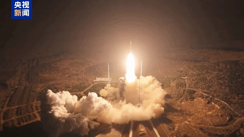
For example, the launch of satellites like the Yaogan-50 03 remote sensing satellite by China, as reported by CGTN, demonstrates the ongoing global investment in this technology. Such satellites are designed for specific purposes, like land survey and disaster relief, highlighting the practical and immediate benefits derived from space-based observation. These missions contribute to a growing network of Earth observation capabilities worldwide.
Challenges and Considerations
Despite the immense benefits of remote sensing satellites, there are also challenges and considerations to address.
Data Access and Cost
While the cost of launching satellites has decreased, acquiring and processing high-resolution satellite data can still be expensive. Ensuring equitable access to this data for researchers, governments, and organizations in developing countries remains a challenge. Efforts are underway to make more data openly available, but significant hurdles persist.
Data Processing and Interpretation
The sheer volume of data generated by modern satellites requires advanced processing capabilities and skilled personnel for interpretation. Developing user-friendly tools and training programs is essential to enable a wider range of users to benefit from remote sensing technology. The complexity of interpreting spectral signatures and understanding atmospheric effects can be a barrier for non-experts.
Ethical and Privacy Concerns
The increasing resolution of satellite imagery raises ethical and privacy concerns, particularly regarding surveillance and the potential misuse of data. Establishing clear guidelines and regulations for the use of satellite imagery is crucial to balance the benefits of the technology with the protection of individual privacy and national security.
International Cooperation and Data Sharing
Effective use of remote sensing for global challenges often requires international cooperation and data sharing. Differences in data policies, technical standards, and political considerations can hinder collaboration. Fostering open dialogue and establishing common frameworks for data exchange are vital for maximizing the benefits of remote sensing on a global scale.
Conclusion
Remote sensing satellites have transformed our ability to observe and understand our planet. From monitoring environmental changes and managing natural disasters to supporting agriculture and urban planning, their applications are vast and continue to expand. As technology advances, we can expect even more sophisticated satellites, more frequent data collection, and more powerful analytical tools, further enhancing our capacity to address global challenges and improve life on Earth. The ongoing development and deployment of these vital tools underscore their indispensable role in scientific research, policy-making, and our collective efforts to build a more sustainable future.
The organization website can be found at CGTN.


Conversation
0 Comments