

Harnessing AI for Extreme Weather: China’s Fengyun Satellite Innovations
Extreme weather events pose a growing threat worldwide, from devastating typhoons to sudden, severe storms. Predicting and monitoring these phenomena accurately and rapidly is crucial for saving lives and protecting property. In this ongoing battle against nature’s fury, artificial intelligence (AI) is emerging as a powerful ally. China has recently taken a significant step forward by unveiling its first suite of AI models designed to work with its Fengyun meteorological satellites, aiming to dramatically improve the monitoring and warning capabilities for extreme weather.
These new AI models represent a leap in how we can interpret the vast amounts of data sent back by weather satellites. By applying advanced machine learning techniques, these systems can analyze complex atmospheric patterns with unprecedented speed and precision. This allows meteorologists to gain deeper insights into the formation, evolution, and potential impact of severe weather events. The development signifies a commitment to leveraging cutting-edge technology to enhance global weather forecasting and disaster preparedness.
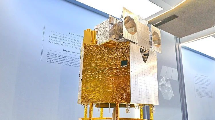
The Fengyun meteorological satellite program is a cornerstone of China’s weather observation infrastructure. With a growing constellation of satellites in orbit, the program provides essential data for weather services both domestically and internationally. The integration of AI into this system promises to unlock new levels of understanding and predictive power, transforming raw satellite imagery into actionable intelligence. This article will explore the specifics of these new AI models, their capabilities, and the broader implications for extreme weather forecasting.
Understanding the Fengyun Satellite System
The Fengyun (FY) meteorological satellite program is China’s ambitious initiative to build a robust and comprehensive Earth observation network. Launched in 1988, the program has steadily grown, deploying a series of geostationary and polar-orbiting satellites. These satellites are equipped with advanced instruments capable of capturing a wide range of atmospheric data, including visible and infrared imagery, temperature profiles, humidity levels, and wind speeds.
Geostationary satellites, like the Fengyun-4 series, orbit the Earth at an altitude of approximately 35,786 kilometers, maintaining a fixed position relative to a point on the equator. This allows them to continuously monitor a vast geographical area, providing a constant stream of data crucial for tracking rapidly developing weather systems. Polar-orbiting satellites, on the other hand, circle the Earth from pole to pole, offering global coverage and detailed vertical profiles of the atmosphere.
The data collected by Fengyun satellites is vital for a multitude of applications, including weather forecasting, climate monitoring, disaster management, and environmental research. China has made a commitment to sharing this valuable data with the international community, with current figures indicating that data from Fengyun satellites is accessible to 141 countries and regions. This global reach underscores the importance of the Fengyun program in contributing to worldwide meteorological understanding and cooperation.
The sheer volume of data generated by these satellites is immense. Traditionally, analyzing this data required significant human effort and time, often involving skilled meteorologists interpreting complex imagery. While human expertise remains indispensable, the advent of AI offers a way to process this data more efficiently, identify subtle patterns, and accelerate the delivery of critical information. This is where the new AI models come into play, designed to augment and enhance the capabilities of the existing Fengyun satellite infrastructure.
The Power of AI in Meteorological Analysis
Artificial intelligence, particularly machine learning and deep learning, has revolutionized many scientific fields, and meteorology is no exception. The ability of AI algorithms to learn from vast datasets, identify complex correlations, and make predictions has opened up new avenues for weather forecasting. In the context of satellite meteorology, AI can process images and sensor data far faster than human analysts, leading to quicker identification of weather phenomena and more timely warnings.
One of the primary advantages of AI in this domain is its capacity for pattern recognition. Weather systems, especially extreme ones, often exhibit subtle visual cues in satellite imagery that can be difficult for the human eye to detect consistently. AI models, trained on thousands or even millions of historical satellite images, can learn to recognize these patterns with remarkable accuracy. This allows for earlier detection of developing storms, more precise tracking of their movement, and better estimation of their intensity.
Furthermore, AI can analyze multiple data streams simultaneously. Weather satellites collect data from various instruments, providing a multi-dimensional view of the atmosphere. AI can integrate information from different sensors, such as infrared, visible light, and microwave imagery, along with atmospheric soundings, to build a more complete picture of the weather situation. This holistic approach leads to more robust and reliable forecasts.
The concept of “nowcasting” is particularly well-suited for AI applications. Nowcasting deals with very short-term weather predictions, typically from a few minutes to a couple of hours ahead. This is critical for phenomena like thunderstorms, heavy rainfall, and hail, which can develop and dissipate rapidly. AI models can continuously analyze incoming satellite data to predict the immediate evolution of these events, providing crucial warnings to areas that might be affected.
The integration of AI with satellite data is not about replacing human meteorologists but about empowering them with advanced tools. AI can automate routine tasks, such as identifying cloud types or tracking storm features, freeing up experts to focus on higher-level analysis, interpretation, and communication of weather information. This synergy between human expertise and artificial intelligence is key to advancing our ability to predict and respond to extreme weather.
Introducing the New Fengyun AI Models
China’s recent unveiling of its first Fengyun satellite AI models marks a significant milestone in the application of artificial intelligence to meteorological forecasting. These models are specifically designed to tackle the challenges posed by extreme weather events, enhancing the operational capabilities of the Fengyun satellite system. Two key models have been highlighted: an intelligent typhoon cloud imagery interpretation model and a severe convection nowcasting warning model.
Intelligent Typhoon Cloud Imagery Interpretation Model
Typhoons are among the most destructive weather phenomena, and their accurate tracking and intensity estimation are paramount for effective disaster management. The intelligent typhoon cloud imagery interpretation model aims to automate and improve this process. This AI model is capable of automatically analyzing various aspects of typhoons directly from satellite imagery.
The model can identify and assess the typhoon’s position, its internal structure, its current intensity, and how it is evolving over time. This is a complex task that traditionally required skilled meteorologists to manually interpret satellite images, a process that can be time-consuming and subject to human variability. By automating this analysis, the AI model can provide consistent and rapid assessments.
A key feature of this model is its ability to generate standardized interpretation text and output visualized products. This means that the AI not only analyzes the typhoon but also produces clear, concise reports and visual aids that meteorologists can readily use. This streamlines the workflow and ensures that critical information is communicated efficiently.
Currently, this model is designed to cover seven distinct types of typhoon features. It performs an interpretation analysis every 15 minutes, which is a significant improvement in the frequency of updates compared to manual methods. Furthermore, the generation of the interpretation text is remarkably fast, taking only about 27 seconds. This rapid processing allows for near real-time monitoring of typhoons as they develop and move across the ocean.
Severe Convection Nowcasting Warning Model
Severe convection refers to atmospheric conditions that can lead to intense thunderstorms, heavy rainfall, hail, and even tornadoes. These events can occur with little warning and have a significant impact on local areas. The severe convection nowcasting warning model is designed to provide earlier and more accurate warnings for these types of events.
This model utilizes continuous observations from the Fengyun-4 meteorological satellite over the preceding two hours. By analyzing this recent history of atmospheric conditions, the AI can predict how cloud imagery is likely to evolve in the near future. This predictive capability is crucial for identifying areas where severe convection is likely to develop.
The primary benefit of this model is its ability to advance the warning lead time. It can predict potential severe convection areas up to four hours in advance. This extended warning period gives authorities and the public more time to prepare, evacuate if necessary, and take protective measures, thereby reducing the potential for casualties and damage.
The development and deployment of these AI models represent a significant advancement in China’s meteorological capabilities. They are designed to work in tandem with the existing Fengyun satellite network, transforming raw data into more precise and timely forecasts for some of the most dangerous weather phenomena.
Enhancing Extreme Weather Monitoring and Warning
The introduction of these AI models is poised to significantly bolster the capabilities of the Fengyun meteorological satellites in monitoring and warning against extreme weather. The enhancements are not just incremental; they represent a fundamental shift in how meteorological data can be processed and utilized. By automating complex analyses and accelerating prediction times, these AI systems directly address the critical need for faster and more accurate weather information.
For typhoons, the intelligent interpretation model provides a consistent and rapid assessment of their characteristics. This is vital for issuing timely and accurate warnings to coastal communities. The ability to analyze position, structure, and intensity every 15 minutes means that forecasters can track a typhoon’s every move with greater confidence. This improved monitoring allows for more precise predictions of landfall locations and potential storm surge impacts, enabling better preparation and response efforts. The standardized output also ensures that all relevant parties receive the same critical information, reducing the potential for miscommunication.
In the case of severe convection, the nowcasting warning model offers a crucial advantage: extended lead times. Predicting these rapidly developing storms up to four hours in advance is a game-changer. It allows for proactive measures to be taken, such as issuing public advisories, preparing emergency services, and advising individuals to seek shelter. This proactive approach is far more effective than reacting to a storm that has already formed. The model’s reliance on recent satellite data ensures that it is capturing the most up-to-date atmospheric conditions, making its short-term predictions highly relevant.
The synergy between these AI models and the Fengyun satellites is particularly powerful. The satellites provide the high-resolution, frequent data needed to train and operate these AI systems effectively. In turn, the AI models extract more value from the satellite data than ever before, turning it into actionable intelligence. This feedback loop of data and advanced processing creates a more sophisticated and responsive weather monitoring system.
Beyond typhoons and severe convection, the underlying AI technologies can potentially be applied to other extreme weather events. For instance, AI could be trained to identify patterns associated with heavy rainfall leading to floods, or the atmospheric conditions conducive to heatwaves or extreme cold snaps. The modular nature of AI development means that these models can be adapted and expanded to cover a wider range of meteorological challenges.
Global Implications and Data Sharing
China’s advancements in satellite meteorology and AI are not confined to its own borders. The Fengyun program has a long-standing commitment to international cooperation, making its data accessible to numerous countries and regions worldwide. This global data-sharing policy means that the benefits of these new AI models could extend far beyond China, contributing to improved weather forecasting and disaster preparedness on a global scale.
When data from Fengyun satellites is shared, it often includes processed products and raw sensor readings. The integration of AI into the processing pipeline means that the data being shared can become even more valuable. For example, if China develops advanced AI-driven typhoon intensity estimations, this information, derived from Fengyun satellite data, can be disseminated to meteorological agencies in other countries. This allows them to benefit from China’s technological advancements without having to replicate the complex AI development process themselves.
This collaborative approach is essential for tackling global challenges like climate change and extreme weather. No single nation can effectively monitor and predict weather patterns that span continents and oceans. By making advanced AI-driven meteorological products available, China is contributing to a more robust global weather observation and forecasting network. This can lead to more accurate international advisories, better coordination during large-scale weather events, and improved understanding of global atmospheric dynamics.
The Fengyun meteorological satellites are already an important component of the global meteorological observation system. With the addition of AI capabilities, their contribution is set to increase significantly. This development highlights the growing importance of international data exchange and technological collaboration in the field of meteorology. As AI technology continues to evolve, its integration with satellite systems will likely become a standard practice, further enhancing our collective ability to understand and respond to the Earth’s complex weather systems.
The accessibility of Fengyun data to 141 countries and regions means that meteorological agencies worldwide can potentially integrate these new AI models into their own forecasting workflows. This could lead to a more harmonized approach to weather prediction and a more unified global response to extreme weather events. The ongoing development and application of AI in weather forecasting underscore a future where technology and international cooperation are key to mitigating the impacts of severe weather.
The Future of AI in Weather Forecasting
The recent introduction of AI models for the Fengyun meteorological satellites is not an endpoint but a significant step in a rapidly evolving field. The future of weather forecasting is undeniably intertwined with the advancement of artificial intelligence and the continued development of sophisticated Earth observation systems. As AI technology matures and satellite capabilities expand, we can anticipate even more profound transformations in our ability to predict and manage weather.
One area of future development will likely involve the creation of more complex and integrated AI models. Instead of specialized models for typhoons or severe convection, we may see AI systems that can simultaneously monitor and predict a wider range of weather phenomena. These models could learn to identify the complex interactions between different atmospheric variables, leading to more holistic and accurate forecasts. For instance, an AI could potentially predict not only the path of a hurricane but also its associated rainfall, wind speeds, and even its potential impact on local weather patterns days in advance.
The increasing resolution and frequency of satellite data will also play a crucial role. As satellites become more advanced, they will capture even more detailed information about the atmosphere. AI models will need to evolve to process this higher-resolution data effectively, unlocking new insights into atmospheric processes. This could lead to breakthroughs in understanding phenomena like microbursts, rapidly intensifying storms, or the precise formation mechanisms of tornadoes.
Furthermore, the application of AI in weather forecasting is likely to extend beyond prediction to impact assessment. AI could be used to analyze real-time data from various sources, including social media and sensor networks, to assess the immediate impact of weather events. This could help emergency responders prioritize their efforts, identify areas most in need of assistance, and provide more targeted warnings to vulnerable populations.
The ethical considerations and challenges associated with AI in weather forecasting will also need to be addressed. Ensuring the accuracy and reliability of AI predictions, maintaining transparency in how these models work, and managing the potential for bias in the data used for training will be important. As AI becomes more integrated into critical decision-making processes, such as issuing disaster warnings, robust validation and oversight will be essential.
Ultimately, the goal is to create a seamless system where satellite data, advanced AI processing, and human expertise work together to provide the most accurate and timely weather information possible. This will empower communities worldwide to better prepare for, respond to, and mitigate the impacts of extreme weather, making our planet a safer place in the face of a changing climate. The Fengyun satellite AI models are a testament to this ongoing journey, showcasing the immense potential of technology to safeguard our future.
Conclusion
The unveiling of China’s first Fengyun satellite AI models marks a pivotal moment in the quest to better understand and predict extreme weather. By integrating artificial intelligence with its advanced meteorological satellite network, China is enhancing its capacity to monitor and warn against threats like typhoons and severe convection with unprecedented speed and accuracy. These AI-driven innovations promise to provide meteorologists with more powerful tools, enabling earlier detection, more precise tracking, and extended warning lead times for dangerous weather events.
The intelligent typhoon cloud imagery interpretation model and the severe convection nowcasting warning model are prime examples of how AI can transform raw satellite data into actionable intelligence. Their ability to automate complex analyses and deliver rapid insights is crucial for effective disaster preparedness and response. Moreover, China’s commitment to sharing Fengyun satellite data globally means that these advancements have the potential to benefit meteorological services and communities worldwide, fostering international cooperation in tackling shared weather challenges.
As AI technology continues to evolve, its role in weather forecasting is set to expand, promising more integrated models, higher-resolution data analysis, and improved impact assessment capabilities. The ongoing development in this field underscores a future where the synergy between sophisticated technology and global collaboration will be essential for navigating the increasing complexities of our planet’s weather systems and building a more resilient world against extreme weather events.


Conversation
0 Comments