

Understanding Earthquake Damage Assessment and Mitigation Strategies
Earthquakes are powerful natural events that can cause widespread destruction. Following a significant seismic event, understanding the extent of the damage is critical for effective rescue, recovery, and rebuilding efforts. This involves a detailed assessment of the physical impact on the ground, structures, and the surrounding environment. Geoscientists play a vital role in this process, using advanced techniques to map surface ruptures, identify hidden fractures, and predict potential secondary hazards like landslides. Their work provides essential data for ensuring safer post-disaster operations and planning resilient communities.
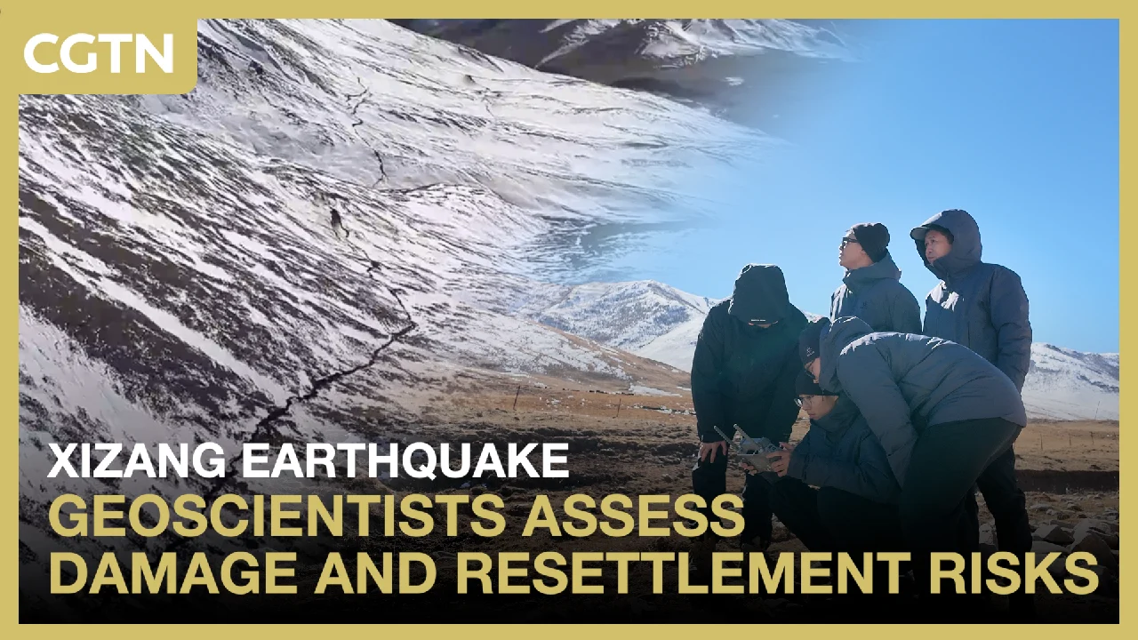
The immediate aftermath of an earthquake presents a complex challenge. Emergency responders need to navigate damaged infrastructure, locate survivors, and provide essential aid. Simultaneously, scientists begin the crucial task of evaluating the earthquake’s impact. This assessment goes beyond visible destruction; it involves understanding the forces that shaped the event and their lingering effects on the landscape. For instance, geoscientists investigating an earthquake in Xizang, as reported by CGTN, used drone footage to reveal surface ruptures caused by a recent seismic event. This visual data, combined with on-the-ground analysis, helps to map the earthquake’s footprint and understand its geological implications.
The process of assessing earthquake damage is multifaceted. It requires a combination of remote sensing technologies, field investigations, and geological expertise. By studying the patterns of ground deformation, scientists can infer the depth and magnitude of the seismic rupture. This information is invaluable for understanding the earthquake’s source and its potential to trigger further seismic activity. Furthermore, identifying surface ruptures is crucial for planning safe routes for rescue teams and for determining areas that are at high risk of collapse or instability.
Beyond immediate structural damage, earthquakes can trigger a cascade of secondary disasters. Landslides, soil liquefaction, and tsunamis (in coastal areas) are all potential consequences that can exacerbate the initial devastation. Geoscientists are instrumental in assessing these secondary risks. By analyzing the geological makeup of an area, its topography, and the extent of ground disturbance, they can predict where landslides are most likely to occur. This foresight allows authorities to evacuate at-risk populations and to implement preventative measures where possible. The insights gained from these assessments are not only vital for immediate response but also for long-term disaster preparedness and urban planning.
The Role of Geoscientists in Post-Earthquake Analysis
Geoscientists are at the forefront of understanding and responding to the aftermath of earthquakes. Their expertise is indispensable for accurately gauging the impact of seismic events and for developing strategies to mitigate future risks. When an earthquake strikes, these specialists deploy a range of tools and methodologies to gather critical data. This includes using drones equipped with high-resolution cameras to map surface changes, employing GPS devices to measure ground displacement, and conducting geological surveys to analyze soil and rock stability.
One of the primary tasks for geoscientists is to identify and map surface ruptures. These are visible cracks or displacements on the Earth’s surface that directly result from the fault movement during an earthquake. Drone footage, as seen in the investigation following the Xizang earthquake, provides an aerial perspective that can quickly reveal the extent and pattern of these ruptures. This information is vital for understanding the fault’s behavior and for identifying areas that are particularly unstable. Mapping these ruptures helps in planning safe access for rescue teams and in assessing the integrity of buildings and infrastructure located nearby.
Beyond surface ruptures, geoscientists also look for evidence of hidden ground fractures. These may not be immediately visible but can still pose significant risks. Techniques such as ground-penetrating radar or seismic surveys can help detect these subsurface disturbances. Understanding the presence and extent of these hidden fractures is crucial for determining the stability of the ground, especially when considering the construction of temporary shelters or permanent rebuilding efforts. Areas with extensive subsurface fracturing may be more prone to settlement or collapse.
Assessing the risk of landslides and other secondary disasters is another critical function of geoscientists. Earthquakes can destabilize slopes, trigger rockfalls, and cause soil liquefaction, where saturated soil loses its strength and behaves like a liquid. By analyzing factors such as slope angle, soil type, the presence of water, and the degree of ground shaking, geoscientists can create hazard maps that identify areas most vulnerable to these secondary effects. This information allows emergency managers to prioritize search and rescue efforts in safer zones and to warn communities about potential dangers.
The data collected by geoscientists informs crucial decisions regarding post-disaster resettlement and rescue operations. For example, knowing the location of major surface ruptures or areas prone to landslides helps authorities avoid establishing temporary camps or permanent settlements in hazardous zones. It also guides the deployment of rescue teams, ensuring they can operate safely and efficiently. Ultimately, the scientific understanding provided by geoscientists is fundamental to building more resilient communities that can better withstand the impacts of future earthquakes.
Technologies and Methods for Damage Assessment
The assessment of earthquake damage has been revolutionized by advancements in technology and scientific methodologies. These tools allow for more rapid, accurate, and comprehensive evaluations of seismic impacts, which are crucial for effective disaster response and recovery. From satellite imagery to sophisticated ground-based sensors, a variety of techniques are employed to understand the scope of destruction.
Remote Sensing Technologies:
Satellite and aerial imagery have become indispensable in earthquake damage assessment. High-resolution images captured before and after an earthquake can reveal significant changes in the landscape and urban areas.
- Satellite Imagery: Satellites equipped with optical or radar sensors can provide broad coverage of affected regions. Radar imagery is particularly useful as it can penetrate cloud cover, which is often present after major storms that can accompany or follow earthquakes. By comparing pre- and post-event imagery, analysts can identify collapsed buildings, damaged roads, and altered landforms.
- Drone Technology: Unmanned aerial vehicles (UAVs), or drones, offer a more flexible and detailed approach. Drones can be deployed quickly to capture high-resolution aerial photographs and videos of specific areas. As seen in the investigation of the Xizang earthquake, drone footage is invaluable for mapping surface ruptures and assessing the condition of infrastructure up close. Drones can also be equipped with thermal cameras to detect heat signatures, which can aid in search and rescue operations.
Geophysical Survey Methods:
These methods are used to investigate the subsurface and understand the geological conditions that influence earthquake damage.
- Ground-Penetrating Radar (GPR): GPR uses radar pulses to image the subsurface. It can detect buried utilities, voids, and fractures, providing insights into the stability of the ground beneath structures and potential areas of liquefaction.
- Seismic Surveys: By generating and recording seismic waves, geoscientists can map subsurface layers and identify fault lines or areas of fractured rock. This helps in understanding the amplification of seismic waves in different geological settings, which can lead to more severe shaking in certain areas.
Geodetic Measurements:
Precise measurements of ground deformation are essential for understanding the earthquake’s source and its impact on the Earth’s crust.
- Global Navigation Satellite Systems (GNSS): Networks of GNSS receivers, including GPS, can measure ground displacement with centimeter or even millimeter accuracy. By analyzing data from these stations, scientists can determine how much the ground has moved horizontally and vertically, providing critical information about the fault slip and the overall strain release.
- InSAR (Interferometric Synthetic Aperture Radar): This satellite-based technique uses radar signals to measure ground deformation over large areas with high precision. InSAR can detect subtle ground movements that might not be visible to the naked eye, helping to map the extent of the earthquake’s influence and identify areas of ongoing instability.
Field Assessment and Mapping:
Despite technological advancements, direct field observation remains crucial.
- Surface Rupture Mapping: Geologists meticulously map the location, length, and displacement of surface ruptures. This involves detailed fieldwork, often using traditional surveying tools alongside GPS devices. This data is fundamental for understanding the fault’s behavior and for establishing building setbacks in seismically active zones.
- Geotechnical Investigations: Soil samples are collected and analyzed to assess soil properties, such as strength and susceptibility to liquefaction. This information is vital for designing foundations and for evaluating the stability of slopes.
The integration of these diverse technologies and methods allows for a comprehensive understanding of earthquake damage. This data-driven approach supports informed decision-making for emergency response, infrastructure repair, and long-term hazard mitigation strategies.
Understanding Surface Ruptures and Ground Fractures
Surface ruptures and ground fractures are direct manifestations of an earthquake’s power, representing the visible scars left on the Earth’s crust. Understanding these features is paramount for assessing seismic hazards and for guiding recovery efforts. These phenomena occur when the movement along a fault line extends to the Earth’s surface, causing the ground to break, shift, or deform.
Surface Ruptures:
A surface rupture is the trace of a fault on the ground’s surface. When an earthquake occurs, the two sides of the fault slip past each other. If this slip extends all the way to the surface, it creates a visible break. The nature of the rupture depends on the type of faulting:
- Strike-Slip Faults: These faults move horizontally. Surface ruptures associated with strike-slip faults often appear as linear scarps or zones of en echelon cracks, where blocks of land slide past each other sideways. Roads, fences, or streams that cross the fault can be visibly offset.
- Dip-Slip Faults: These faults involve vertical movement.
- Normal Faults: The hanging wall moves down relative to the footwall, creating a step-like feature called a scarp. The ground surface appears to drop down on one side of the fault.
- Reverse Faults (and Thrust Faults): The hanging wall moves up relative to the footwall. This results in the ground being pushed upwards, forming a steep scarp or a series of compressional ridges.
The length and displacement of a surface rupture provide clues about the earthquake’s magnitude and the amount of energy released. Geoscientists meticulously map these ruptures, recording their precise location, orientation, and the amount of slip. This data is crucial for seismic hazard assessments, helping to identify active fault zones and to estimate the potential for future earthquakes. For urban planning, understanding surface rupture zones is critical, as building directly on or across an active fault trace is extremely hazardous.
Ground Fractures:
Ground fractures are cracks or fissures that appear in the ground as a result of seismic shaking. Unlike surface ruptures, which are directly caused by fault movement, ground fractures can be triggered by the shaking itself, even in areas far from the main fault. These fractures can occur in various forms:
- Tensional Fractures: These are cracks that open up due to the ground being pulled apart. They often appear as irregular, branching cracks.
- Shear Fractures: These form when the ground is subjected to sideways forces during shaking.
- Concentric Fractures: These can form around areas of ground settlement or subsidence.
- Radial Fractures: These spread outwards from a central point, often associated with localized ground deformation.
Ground fractures can occur in soil, rock, and even in artificial surfaces like roads and pavements. They can be shallow or extend to considerable depths. The presence of ground fractures can indicate areas of instability, particularly in slopes or near existing structures. They can also be precursors to more significant ground failures, such as landslides or soil liquefaction.
Investigating Hidden Fractures:
Sometimes, the most dangerous fractures are those that are not immediately visible. These “hidden” fractures can exist beneath the surface, within soil layers or bedrock. Detecting these subsurface fractures often requires specialized geophysical techniques.
- Ground-Penetrating Radar (GPR): As mentioned earlier, GPR can be used to image the subsurface and identify anomalies that may indicate fractures or voids.
- Electrical Resistivity Tomography (ERT): This method measures the electrical resistance of the ground, which can vary depending on the presence of water-filled fractures or different soil types.
- Seismic Refraction/Reflection: Analyzing how seismic waves travel through the ground can reveal discontinuities, including fractures.
Identifying hidden fractures is essential for ensuring the safety of construction projects, underground utilities, and for assessing the stability of slopes that might appear stable on the surface. The investigation of these features, both visible and hidden, is a core component of post-earthquake damage assessment, providing a detailed picture of the ground’s response to seismic forces.
Assessing Secondary Disaster Risks: Landslides and Liquefaction
Earthquakes are not just about the initial ground shaking; they often trigger a cascade of secondary disasters that can be equally, if not more, destructive. Among the most significant of these are landslides and soil liquefaction. Geoscientists play a critical role in assessing the risks associated with these phenomena, helping communities prepare for and mitigate their impacts.
Landslides:
Earthquakes can destabilize slopes by violently shaking the ground. This shaking can reduce the internal friction within soil and rock, causing them to lose their ability to resist gravity. Factors that increase landslide risk after an earthquake include:
- Steep Slopes: Areas with significant elevation changes are inherently more prone to landslides.
- Unconsolidated Materials: Soils and weathered rock that are loose and poorly compacted are more easily dislodged.
- Water Content: Saturated soils are heavier and have reduced shear strength, making them more susceptible to failure. Earthquakes can also rupture underground water sources, leading to increased pore water pressure on slopes.
- Previous Landslides: Areas that have experienced landslides in the past are often more vulnerable due to existing weaknesses in the slope.
Geoscientists assess landslide risk by analyzing these factors. They create hazard maps that delineate areas with high, moderate, and low susceptibility to earthquake-induced landslides. These maps are based on detailed geological surveys, topographic analysis, and studies of rainfall and seismic history. During post-earthquake assessments, they specifically look for signs of recent slope movement, such as fresh scarps, displaced trees, or debris flows. Drone imagery and satellite data are invaluable for quickly identifying potential slide areas over large regions.
Soil Liquefaction:
Soil liquefaction is a phenomenon where saturated, granular soils (like sands and silts) temporarily lose their strength and stiffness during an earthquake. This occurs because the seismic shaking causes the water pressure between soil particles to increase. When this pore water pressure exceeds the pressure exerted by the soil particles themselves, the soil behaves like a liquid. The consequences of liquefaction can be severe:
- Loss of Bearing Capacity: Buildings and other structures founded on liquefied soil can sink, tilt, or collapse because the ground beneath them can no longer support their weight.
- Lateral Spreading: Large blocks of intact ground can move horizontally across liquefied layers, causing significant damage to infrastructure.
- Sand Boils (Sand Volcanoes): Water and liquefied sand can erupt onto the ground surface, forming cone-shaped mounds of sand.
- Settlement: Even after the shaking stops, the ground can settle as the liquefied soil consolidates.
Assessing liquefaction potential involves evaluating several key factors:
- Soil Type: Loose, saturated sands and silts are most susceptible.
- Water Table Depth: A shallow water table increases the likelihood of liquefaction.
- Earthquake Intensity: Stronger and longer-duration shaking increases the risk.
- Overlying Soil Layers: The presence of impermeable layers can trap water and increase pore pressure.
Geoscientists use soil boring data, cone penetration tests, and seismic surveys to evaluate these factors. They then create liquefaction hazard maps, identifying areas where this phenomenon is most likely to occur. During post-earthquake assessments, they look for evidence of sand boils, ground settlement, and tilted structures as indicators of liquefaction. Understanding these risks is crucial for designing earthquake-resistant foundations and for planning safe development in seismically active regions.
By diligently assessing the risks of landslides and liquefaction, geoscientists provide essential information that enables communities to prepare for, respond to, and recover from the devastating secondary effects of earthquakes. This proactive approach is fundamental to building resilience against natural hazards.
Implications for Safer Resettlement and Rescue Operations
The detailed analysis of earthquake damage, particularly the identification of surface ruptures, hidden fractures, and secondary disaster risks, has profound implications for how we conduct rescue operations and plan for post-disaster resettlement. Ensuring the safety of both rescue personnel and survivors is paramount, and scientific data provides the foundation for making informed decisions.
Enhancing Rescue Operations:
When an earthquake strikes, the immediate priority is to save lives. However, the very environment where rescue efforts take place can be hazardous.
- Route Planning: Mapping surface ruptures and major ground fractures is essential for planning safe access routes for emergency vehicles and rescue teams. Roads that are broken, offset, or covered by debris can be impassable or dangerous. Identifying stable pathways is critical for timely intervention.
- Hazard Avoidance: Understanding areas prone to landslides, rockfalls, or liquefaction allows rescue teams to avoid deploying personnel into immediate danger. For example, if a slope is identified as highly unstable, rescue efforts in that specific area might need to be approached with extreme caution or from a different angle.
- Structural Assessment: While structural engineers typically lead building assessments, geoscientists can provide context about ground conditions that might affect structural stability. For instance, if a building is situated on an area known to be susceptible to liquefaction, its structural integrity might be further compromised even if the building itself appears intact.
- Resource Deployment: Knowledge of the earthquake’s impact zone, including the extent of ground deformation, helps in strategically deploying resources and personnel to the areas where they are most needed and can operate most effectively.
Planning for Safer Resettlement:
Following the immediate rescue phase, attention turns to providing shelter and support for displaced populations. This is where long-term planning based on geological assessments becomes vital.
- Site Selection for Temporary Shelters: Temporary camps for displaced individuals must be located in areas that are safe from immediate seismic hazards and secondary disasters. This means avoiding zones with major surface ruptures, unstable slopes, or areas prone to liquefaction. Geological hazard maps are indispensable tools for selecting appropriate sites.
- Permanent Reconstruction: When rebuilding communities, selecting locations for permanent housing and critical infrastructure (hospitals, schools, government buildings) requires careful consideration of geological risks. Building on or near active fault lines or in landslide-prone areas significantly increases future vulnerability. Understanding the historical seismic activity and the potential for future events is key to making resilient choices.
- Infrastructure Development: Planning for the reconstruction of roads, bridges, utilities (water, power, communication), and other essential infrastructure must account for the geological conditions. Designing these systems to withstand seismic forces and to avoid hazardous ground conditions is a critical aspect of long-term safety. For example, pipelines crossing fault zones need special flexible joints to accommodate ground movement.
- Community Education and Preparedness: The findings from geological assessments can be used to educate communities about the risks they face and to develop effective preparedness plans. This includes understanding evacuation routes, identifying safe zones, and knowing how to respond to aftershocks or secondary events.
The integration of scientific understanding into disaster response and recovery planning transforms reactive measures into proactive strategies. By prioritizing safety based on rigorous geological analysis, communities can not only recover more effectively but also build back stronger and more resilient to future seismic events. The work of geoscientists, therefore, extends far beyond the initial scientific curiosity; it directly contributes to saving lives and safeguarding communities for the future.
Case Study: Earthquake Damage Assessment in Xizang
The recent earthquake in Xizang, as documented by CGTN, provides a real-world example of how geoscientists assess earthquake damage and the importance of their findings. This case highlights the application of modern technologies and the critical insights gained from such investigations.
Following the earthquake, geoscientists from the China University of Geosciences (Wuhan) were dispatched to the affected region. Their mission was to investigate the damage, uncover hidden ground fractures, and assess the risks of secondary disasters like landslides. This type of on-the-ground investigation, complemented by remote sensing, is standard practice in modern earthquake response.
Utilizing Drone Technology:
A key tool employed in this assessment was drone technology. Drone footage provided detailed aerial views of the earthquake’s impact. This allowed the geoscientists to:
- Visualize Surface Ruptures: The drones captured images revealing surface ruptures caused by the earthquake. Mapping these ruptures is crucial for understanding the extent of the fault’s movement at the surface and for identifying areas of significant ground deformation. This visual data helps in creating detailed maps of the earthquake’s footprint.
- Identify Damaged Infrastructure: The aerial perspective enabled a rapid overview of damage to buildings, roads, and bridges. This helps emergency managers prioritize areas for immediate attention and assess the accessibility of different locations.
- Detect Potential Hazards: Drones can also help identify signs of instability, such as cracked slopes or areas of disturbed ground that might indicate a risk of landslides.
On-Site Geological Investigations:
Beyond aerial surveys, the geoscientists conducted detailed field investigations. This involved:
- Mapping Fault Traces: Geologists meticulously walked the affected areas to map the precise location and characteristics of the surface ruptures. This includes measuring the amount of displacement (how much the ground moved horizontally or vertically) and the length of the rupture.
- Assessing Ground Conditions: They examined the types of soil and rock present, looking for evidence of liquefaction or other ground failures. This involves collecting samples and performing field tests.
- Evaluating Landslide Risk: The team assessed the stability of slopes in the vicinity of the earthquake’s epicenter and along the fault rupture. They looked for pre-existing weaknesses and signs of recent movement triggered by the shaking.
Insights for Post-Disaster Planning:
The findings from this assessment have direct applications for the region’s recovery and future safety:
- Informing Rescue Efforts: The detailed maps of surface ruptures and hazardous areas help guide rescue teams, ensuring they can operate safely and efficiently. Knowing where the ground is unstable or impassable is critical for planning search and rescue missions.
- Guiding Resettlement: The data gathered is vital for selecting safe locations for temporary shelters and for long-term reconstruction. Areas identified as high-risk for landslides or ground failure should be avoided for new development.
- Improving Future Preparedness: Understanding how the local geology responded to this earthquake provides valuable data for refining seismic hazard models and for developing more effective building codes and land-use planning regulations in the region.
The investigation in Xizang exemplifies the crucial role geoscientists play in understanding the complex impacts of earthquakes. By combining advanced technology with rigorous field science, they provide the essential knowledge needed to respond effectively to disasters and to build more resilient communities in seismically active zones.
Building Resilient Communities: Long-Term Strategies
The immediate aftermath of an earthquake is a period of crisis management, but the true measure of a community’s strength lies in its ability to rebuild and prepare for the future. Building resilience against earthquakes is a long-term endeavor that requires a multi-faceted approach, integrating scientific understanding, robust engineering, effective policy, and community engagement.
1. Advanced Seismic Hazard Assessment:
The foundation of resilience is a thorough understanding of the seismic risks a region faces. This involves:
- Detailed Geological Mapping: Identifying active fault lines, understanding their slip rates, and characterizing the types of ground deformation they can produce.
- Seismic Microzonation: Dividing an area into zones based on expected ground shaking intensity, soil conditions, and susceptibility to secondary hazards like liquefaction and landslides. This helps tailor building codes and land-use planning to specific local risks.
- Probabilistic Seismic Hazard Analysis (PSHA): Estimating the likelihood of earthquakes of certain magnitudes occurring within a given timeframe, providing a statistical basis for risk assessment.
2. Stringent Building Codes and Engineering Practices:
Resilient infrastructure is built to withstand seismic forces. This requires:
- Earthquake-Resistant Design: Implementing building codes that mandate specific design standards for structures, ensuring they can absorb seismic energy without collapsing. This includes requirements for foundation design, structural reinforcement, and material selection.
- Retrofitting Existing Structures: Many older buildings may not meet current seismic standards. A program to identify and retrofit vulnerable buildings, especially critical facilities like hospitals and schools, is essential.
- Innovative Materials and Techniques: Research and development into new materials and construction methods that offer enhanced seismic performance, such as base isolation or energy dissipation devices.
3. Smart Land-Use Planning:
Where and how communities are built significantly impacts their vulnerability.
- Avoiding High-Risk Zones: Prohibiting or strictly regulating construction in areas identified as highly susceptible to surface rupture, landslides, liquefaction, or severe ground shaking.
- Developing Safe Evacuation Routes: Planning and maintaining clear, accessible evacuation routes that are themselves designed to withstand seismic events.
- Strategic Placement of Critical Facilities: Ensuring that essential services like hospitals, fire stations, and emergency response centers are located in areas with the lowest seismic risk and are designed to remain operational after an earthquake.
4. Robust Emergency Preparedness and Response Systems:
Effective preparedness ensures a swift and organized response when disaster strikes.
- Early Warning Systems: Implementing systems that can detect earthquakes and provide advance warning, allowing people to take protective actions.
- Well-Trained Response Teams: Equipping and training emergency responders, including search and rescue, medical personnel, and hazard assessment teams.
- Public Education and Drills: Regularly educating the public about earthquake safety, evacuation procedures, and what to do during and after an earthquake. Conducting drills helps reinforce these practices.
- Resource Stockpiling: Ensuring adequate supplies of food, water, medical equipment, and temporary shelter materials are available.
5. Community Engagement and Education:
Resilience is a collective effort.
- Public Awareness Campaigns: Raising awareness about seismic risks and the importance of preparedness measures.
- Involving Local Communities: Engaging residents in the planning process, incorporating local knowledge, and fostering a sense of shared responsibility for safety.
- Promoting a Culture of Preparedness: Encouraging individuals and families to develop their own emergency plans and to have essential supplies readily available.
By systematically addressing these interconnected strategies, communities can significantly reduce their vulnerability to earthquakes. The scientific understanding of earthquake processes, coupled with diligent engineering, thoughtful planning, and active community participation, forms the bedrock of a truly resilient society capable of weathering seismic challenges.
Conclusion
The assessment of earthquake damage is a complex but vital process that extends far beyond the immediate visual destruction. Geoscientists play an indispensable role, employing advanced technologies and rigorous methodologies to map surface ruptures, identify hidden ground fractures, and evaluate the risks of secondary disasters like landslides and liquefaction. This scientific understanding is not merely academic; it directly informs critical decisions during rescue operations, guiding teams through hazardous terrain and helping to avoid immediate dangers. Furthermore, it provides the essential data for planning safer resettlement and long-term reconstruction efforts, ensuring that communities rebuild in ways that minimize future vulnerability. By integrating geological insights into every stage of disaster management, from initial response to permanent rebuilding, we can foster more resilient communities capable of withstanding the powerful forces of nature. The ongoing study and application of earthquake science are fundamental to safeguarding lives and building a safer future.



Conversation
0 Comments