

Jilin-1 Satellites: A New Perspective on Earth Observation
In the rapidly advancing field of space technology, satellite imaging plays a critical role in understanding our planet. From environmental monitoring to urban planning, the ability to capture detailed views of Earth’s surface is invaluable. Among the leading innovations in this sector are China’s Jilin-1 satellites, a constellation designed to provide high-resolution optical remote sensing data. Developed by Chang Guang Satellite Technology, this ambitious project has significantly expanded China’s capabilities in space-based observation.
The Jilin-1 constellation represents a major leap forward in remote sensing technology. Its primary objective is to offer detailed, real-time imagery of various regions across the globe. This capability is crucial for a wide range of applications, including disaster management, agricultural assessment, and infrastructure development. The satellites are equipped with advanced sensors capable of capturing images with remarkable clarity, allowing for the identification of even small features on the ground. This level of detail is essential for accurate analysis and informed decision-making in numerous fields.
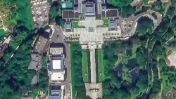
One of the most compelling demonstrations of the Jilin-1 satellites’ power came with the release of high-resolution images of China’s Taiwan region. These images, captured to mark the 81st anniversary of Taiwan’s restoration from Japanese colonial rule, showcased the satellites’ ability to provide stunningly clear views of streets, landmarks, and natural landscapes. The collection included detailed perspectives of Taipei City and the scenic Sun Moon Lake, offering a unique vantage point from space. Such detailed imagery not only serves scientific and practical purposes but also provides a new way to visualize and understand geographical areas.
The Jilin-1 program is more than just a collection of individual satellites; it is a comprehensive optical remote sensing network. This network is designed for continuous operation and data acquisition, ensuring that up-to-date information is always available. The scale of the Jilin-1 constellation is impressive, with approximately 141 satellites currently in orbit. This large number allows for frequent revisits of target areas, increasing the chances of capturing images under optimal conditions and providing a more dynamic view of Earth’s changes over time. The synergy between these numerous satellites enhances the overall effectiveness and data output of the network.
The technological advancements behind the Jilin-1 satellites are a testament to China’s growing expertise in space exploration and satellite technology. The development and deployment of such a sophisticated constellation require significant investment in research, engineering, and manufacturing. Chang Guang Satellite Technology has been at the forefront of this effort, pushing the boundaries of what is possible in remote sensing. Their work on the Jilin-1 program underscores the importance of space-based observation in the modern era and highlights the potential for further innovation in the years to come.
The Jilin-1 Satellite Constellation: A Technological Marvel
The Jilin-1 satellite constellation is a groundbreaking initiative by Chang Guang Satellite Technology, a prominent Chinese aerospace company. This constellation is not a single satellite but a sophisticated system comprising multiple satellites working in unison. The primary goal of Jilin-1 is to provide high-resolution optical remote sensing data, which is essential for a wide array of applications. The development of this constellation marks a significant milestone in China’s efforts to enhance its Earth observation capabilities.
At its core, the Jilin-1 system is designed to capture detailed images of the Earth’s surface from space. Unlike traditional remote sensing satellites that might offer broader but less detailed views, Jilin-1 satellites are engineered for exceptional clarity. This high resolution allows users to distinguish between small objects, observe subtle changes in the environment, and gain a more granular understanding of geographical features. The technology employed ensures that the images produced are not only visually striking but also scientifically accurate and practically useful.
The Jilin-1 constellation is comprised of various types of satellites, each with specific functions. This includes satellites designed for multispectral imaging, which can capture light across different parts of the electromagnetic spectrum, providing information beyond what the human eye can see. There are also satellites dedicated to capturing panchromatic images, which offer higher spatial resolution in black and white, and others for video imaging, allowing for the observation of dynamic events in near real-time. This diverse range of capabilities makes the Jilin-1 constellation a versatile tool for a multitude of users.
The operational scale of the Jilin-1 constellation is one of its most impressive features. With approximately 141 satellites currently in orbit, it represents one of the largest constellations of its kind. This large number of satellites ensures frequent coverage of any given area on Earth. Frequent revisits are critical for monitoring dynamic processes, such as weather patterns, agricultural growth, or urban development. It also increases the probability of obtaining cloud-free images, which is a common challenge in optical remote sensing. The sheer number of satellites allows for a rapid data acquisition cycle, making the information gathered highly relevant and timely.
Chang Guang Satellite Technology’s commitment to innovation is evident in the continuous development and expansion of the Jilin-1 constellation. The company has a vision for a more extensive network that will further enhance Earth observation capabilities. This ongoing development suggests a long-term strategy to maintain a leading position in the global satellite imaging market and to provide increasingly sophisticated services to a growing user base. The success of Jilin-1 is a testament to their dedication and technical prowess in the highly competitive aerospace industry.
Applications of Jilin-1 Satellite Imagery
The high-resolution imagery provided by the Jilin-1 satellite constellation has a vast range of practical applications across numerous sectors. The detailed data captured by these satellites offers unprecedented insights into the Earth’s surface, supporting critical decision-making and advancing scientific understanding. The versatility of the Jilin-1 system makes it an invaluable asset for governments, businesses, and research institutions worldwide.
One of the most significant areas of application is environmental monitoring. Jilin-1 satellites can track changes in land cover, deforestation, and the extent of natural disasters like floods, wildfires, and droughts. The high resolution allows for precise mapping of affected areas, aiding in disaster response and recovery efforts. For instance, detailed images can help identify damaged infrastructure, assess the severity of environmental impacts, and guide the allocation of resources. Monitoring water bodies, ice caps, and vegetation health are also key environmental uses, providing data for climate change research and conservation efforts.
In urban planning and management, Jilin-1 imagery offers detailed views of urban landscapes. Planners can use this data to monitor urban sprawl, assess the condition of infrastructure such as roads and buildings, and identify areas for development or improvement. The ability to see street-level details from space can assist in traffic management studies, the planning of public transportation routes, and the assessment of urban heat islands. This granular view supports the creation of more sustainable and efficient cities.
The agricultural sector greatly benefits from Jilin-1’s capabilities. Farmers and agricultural scientists can use the satellite data to monitor crop health, assess soil conditions, and estimate yields. By analyzing spectral information, it’s possible to detect early signs of disease or nutrient deficiencies in crops, allowing for timely intervention. Precision agriculture, which involves tailoring farming practices to specific field conditions, relies heavily on such detailed spatial data. This leads to optimized resource use, reduced waste, and increased food production.
Resource exploration and management also find significant value in Jilin-1 imagery. Geologists and mining companies can use the high-resolution images to identify potential mineral deposits and monitor mining operations. The satellites can help in mapping geological formations and assessing the environmental impact of resource extraction. Similarly, in forestry, detailed imagery aids in forest inventory, monitoring logging activities, and detecting illegal deforestation.
Furthermore, Jilin-1 satellites play a role in national security and defense. High-resolution imagery is crucial for surveillance, reconnaissance, and mapping of strategic areas. The ability to obtain detailed views of terrain, infrastructure, and potential threats from space provides valuable intelligence for defense agencies. This capability supports border monitoring, disaster assessment in remote regions, and overall situational awareness.
The scientific research community utilizes Jilin-1 data for a wide range of studies, from geology and hydrology to climatology and ecology. The detailed and frequent imagery allows researchers to observe and analyze Earth processes with greater accuracy and scope than ever before. This contributes to a deeper understanding of our planet and the complex systems that govern it.
Finally, the commercial sector benefits from Jilin-1 imagery for applications such as real estate development, insurance risk assessment, and logistics. Companies can use the data for site selection, property valuation, and monitoring assets. The availability of detailed, up-to-date imagery empowers businesses to make more informed strategic decisions, optimize operations, and identify new opportunities.
High-Resolution Imaging: The Jilin-1 Advantage
The defining characteristic of the Jilin-1 satellite constellation is its ability to capture exceptionally high-resolution images. This capability sets it apart from many other Earth observation systems and unlocks a new level of detail for analysis. High resolution in satellite imagery refers to the size of the smallest feature that can be distinguished on the ground. For Jilin-1, this means being able to see objects that are mere centimeters or decimeters across, depending on the specific sensor and satellite in the constellation.
This level of detail is achieved through advanced optical technology and sophisticated satellite design. The cameras and sensors onboard the Jilin-1 satellites are engineered to capture a broad spectrum of light with remarkable precision. When combined with the satellites’ orbital parameters and advanced image processing techniques, the result is imagery that can rival aerial photography in clarity, but with the advantage of global coverage and frequent revisits.
The benefits of such high resolution are manifold. In urban environments, for example, it allows for the identification of individual vehicles, distinct buildings, and even changes in road surfaces. This granular view is invaluable for urban planning, traffic analysis, and infrastructure monitoring. Imagine being able to track the construction progress of a new building, assess the condition of a specific bridge, or monitor the flow of traffic on a particular street, all from space.
For environmental applications, high resolution means being able to detect subtle changes that might be missed by lower-resolution systems. This could include the early signs of disease in a small patch of forest, the precise extent of pollution in a river, or the detailed mapping of biodiversity hotspots. In agriculture, it allows for the monitoring of individual plants or small plots of land, enabling highly targeted interventions for crop management.
The Jilin-1 constellation’s ability to provide video imagery at high resolution further enhances its utility. This allows for the observation of dynamic events, such as the movement of ships, the progress of construction projects, or the behavior of wildlife. Real-time or near-real-time video feeds can be critical for situations requiring immediate situational awareness and rapid response.
Moreover, the Jilin-1 constellation is designed to provide multispectral and hyperspectral data alongside panchromatic (black and white) and color imagery. Multispectral data captures information in specific bands of the electromagnetic spectrum, which can reveal characteristics of objects not visible to the naked eye, such as the health of vegetation or the composition of minerals. Hyperspectral data captures even more narrow spectral bands, offering an even richer dataset for detailed analysis.
The combination of high spatial resolution, video capabilities, and multispectral/hyperspectral sensing makes the Jilin-1 constellation a powerful tool for a wide range of users. It provides a level of detail that was previously unattainable or prohibitively expensive, democratizing access to advanced Earth observation data and fostering innovation across various fields. The continuous expansion and technological refinement of the Jilin-1 system promise even greater capabilities in the future, solidifying its position as a leader in the global remote sensing market.
The Jilin-1 Network: Scale and Coverage
The Jilin-1 satellite constellation is distinguished not only by the quality of its imagery but also by its sheer scale and the extensive coverage it provides. With approximately 141 satellites currently operational, it represents one of the most significant constellations of Earth observation satellites in the world. This large number is not arbitrary; it is a strategic design choice aimed at maximizing the utility and efficiency of the system.
The primary advantage of a large constellation like Jilin-1 is the increased revisit frequency. Revisit frequency refers to how often a satellite can capture images of the same location on Earth. For many applications, especially those involving dynamic processes, frequent revisits are essential. For example, monitoring weather patterns, tracking the progress of agricultural crops, or observing the aftermath of a natural disaster requires data that is as up-to-date as possible. A constellation with many satellites can cover the globe more rapidly, ensuring that any given point is imaged multiple times a day or at least several times a week.
This high revisit capability is crucial for overcoming the limitations of optical remote sensing, such as cloud cover. Clouds can obscure the Earth’s surface, rendering images unusable for certain applications. With a large constellation, if one imaging opportunity is missed due to clouds, there is a higher probability that another satellite will capture a clear image of the same area soon after. This redundancy and frequency significantly improve the reliability of data acquisition.
Beyond revisit frequency, the scale of the Jilin-1 constellation also allows for broader geographical coverage. While individual satellites have a specific field of view, the collective coverage of 141 satellites ensures that vast swathes of the planet can be monitored. This global reach is vital for international environmental monitoring, disaster relief coordination, and global resource management initiatives.
The Jilin-1 constellation is also designed to be a network, meaning the satellites can potentially work together or be managed in a coordinated manner. This allows for more efficient tasking and data collection. For instance, specific areas of interest can be prioritized, and the constellation can be directed to gather data from multiple angles or at different times to provide a more comprehensive understanding.
The development and maintenance of such a large constellation require significant logistical and technical expertise. Chang Guang Satellite Technology has demonstrated its capacity to design, launch, and operate a complex network of satellites. This includes managing orbital positions, ensuring communication links, and processing the enormous volume of data generated by so many active satellites.
The sheer number of Jilin-1 satellites also contributes to the system’s resilience. If one satellite experiences an issue, the overall mission can continue with minimal disruption, as other satellites can compensate for the loss. This redundancy enhances the reliability and longevity of the Earth observation service provided by the constellation.
In summary, the scale of the Jilin-1 constellation, with its approximately 141 satellites, is a key factor in its effectiveness. It enables high revisit rates, broad geographical coverage, improved data reliability, and operational resilience. This extensive network positions Jilin-1 as a leading force in global Earth observation, providing valuable data for a diverse range of applications and users worldwide.
The Future of Earth Observation with Jilin-1
The Jilin-1 satellite constellation represents a significant advancement in Earth observation technology, and its impact is poised to grow even larger in the future. Chang Guang Satellite Technology continues to innovate, with plans for further expansion and technological upgrades to the constellation. This forward-looking approach ensures that Jilin-1 remains at the cutting edge of remote sensing capabilities.
One of the key areas for future development is the enhancement of sensor technology. Future Jilin-1 satellites are likely to feature even higher resolution sensors, capable of capturing finer details than ever before. This could include advancements in spectral resolution, allowing for more precise identification of materials and conditions on the ground, and temporal resolution, providing even more frequent imaging opportunities. The development of synthetic aperture radar (SAR) capabilities, which can penetrate clouds and operate day or night, could also be integrated into future iterations of the constellation, complementing the optical sensors.
The expansion of the constellation itself is also a likely trajectory. As demand for high-quality Earth observation data grows, so too will the need for more satellites to provide comprehensive global coverage and increased revisit frequencies. Chang Guang Satellite Technology may aim to significantly increase the number of satellites in orbit, further solidifying Jilin-1’s position as a dominant player in the market. This expansion could also involve deploying satellites in different orbital configurations to optimize coverage and data acquisition strategies.
Artificial intelligence (AI) and machine learning (ML) are expected to play an increasingly important role in the processing and analysis of Jilin-1 data. As the volume of data generated by the constellation continues to grow exponentially, AI and ML algorithms will be essential for automating tasks, identifying patterns, and extracting meaningful insights efficiently. This could lead to the development of automated change detection systems, predictive modeling for environmental events, and more sophisticated analytical tools for users.
The integration of Jilin-1 data with other data sources, such as ground-based sensors, social media data, and weather models, will also be a key area of development. By fusing data from multiple sources, a more holistic and accurate understanding of Earth’s systems can be achieved. This multi-source data approach will enable more complex analyses and support more informed decision-making in areas like climate modeling, disaster preparedness, and sustainable development.
Furthermore, the commercialization and accessibility of Jilin-1 data are likely to expand. As the technology matures and operational costs decrease, more organizations and individuals will be able to access and utilize this valuable information. This could involve the development of user-friendly platforms, cloud-based data processing services, and tailored solutions for specific industries. The goal will be to make sophisticated Earth observation capabilities accessible to a broader audience, fostering innovation and driving progress across various sectors.
The ongoing development of the Jilin-1 constellation by Chang Guang Satellite Technology signifies a commitment to pushing the boundaries of Earth observation. The future promises even more advanced capabilities, greater coverage, and more intelligent data analysis, all of which will contribute to a deeper understanding of our planet and a more sustainable future. The Jilin-1 program is not just about satellites; it’s about providing the critical data needed to address some of the world’s most pressing challenges.
Conclusion
The Jilin-1 satellite constellation, developed by Chang Guang Satellite Technology, stands as a remarkable achievement in the field of Earth observation. With its extensive network of approximately 141 satellites, Jilin-1 provides high-resolution optical remote sensing data that offers unprecedented detail and coverage of our planet. The constellation’s capabilities extend across a wide array of applications, from environmental monitoring and urban planning to agriculture and national security, demonstrating its immense value to diverse sectors.
The advantage of Jilin-1 lies in its advanced technology, enabling the capture of incredibly detailed imagery and even video from space. This high resolution allows for the identification of small features, monitoring of subtle changes, and a more granular understanding of geographical areas. Coupled with its large scale, the constellation ensures frequent revisits and reliable data acquisition, overcoming common challenges like cloud cover and providing timely information for dynamic processes.
Looking ahead, the future of Jilin-1 appears bright, with ongoing advancements in sensor technology, potential constellation expansion, and the integration of AI and machine learning for data analysis. These developments promise to further enhance Earth observation capabilities, making data more accessible and actionable. The Jilin-1 program is not just a technological feat; it is a vital tool for understanding and managing our planet, contributing to scientific discovery, sustainable development, and informed decision-making on a global scale.


Conversation
0 Comments